IMAGES TAKEN NEAR TO
Gordon Close, LEEK, ST13 8NZ
Introduction
This page details the photographs taken nearby to Gordon Close, ST13 8NZ by members of the Geograph project.
The Geograph project started in 2005 with the aim of publishing, organising and preserving representative images for every square kilometre of Great Britain, Ireland and the Isle of Man.

There are currently over 7.5m images from over14,400 individuals and you can help contribute to the project by visiting https://www.geograph.org.uk
Image Map (Loading...)


Getting Data...Please wait
Leaflet Map data © OpenStreetMap
Images are licensed for reuse under creativecommons.org/licenses/by-sa/2.0
Notes
- Clicking on the map will re-center to the selected point.
- The higher the marker number, the further away the image location is from the centre of the postcode.
Image Listing (4 Images Found)
Images are licensed for reuse under creativecommons.org/licenses/by-sa/2.0
Image
Details
Distance
1
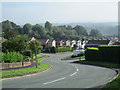
Wallbridge Drive, Leek
Looking along Wallbridge Drive; residential area west of the town centre. In the middle distance is the junction with Beggars Lane on the left.
Image: © David Weston
Taken: 24 Sep 2013
0.10 miles
2
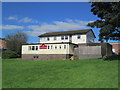
The Prince of Wales, Leek
A pub on Fernwood Drive, among houses of a similar age to this.
Image: © David Weston
Taken: 17 Sep 2019
0.11 miles
3
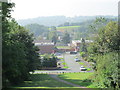
Woodcroft, Leek
At the foot of the hill is Campbell Avenue; Thornhill Road, right of centre, joins Wallbridge Drive further away. Beyond the junction is Wallbridge Precinct.
Image: © David Weston
Taken: 24 Sep 2013
0.15 miles
4
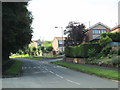
Wallbridge Drive, Leek
Looking south along Wallbridge Drive. Near the camera is Edgehill Road on the left; further away is Coopers Close on the right.
Image: © David Weston
Taken: 24 Sep 2013
0.22 miles