IMAGES TAKEN NEAR TO
Oakwood Road, LEEK, ST13 8LW
Introduction
This page details the photographs taken nearby to Oakwood Road, ST13 8LW by members of the Geograph project.
The Geograph project started in 2005 with the aim of publishing, organising and preserving representative images for every square kilometre of Great Britain, Ireland and the Isle of Man.

There are currently over 7.5m images from over14,400 individuals and you can help contribute to the project by visiting https://www.geograph.org.uk
Image Map (Loading...)


Getting Data...Please wait
Leaflet Map data © OpenStreetMap
Images are licensed for reuse under creativecommons.org/licenses/by-sa/2.0
Notes
- Clicking on the map will re-center to the selected point.
- The higher the marker number, the further away the image location is from the centre of the postcode.
Image Listing (12 Images Found)
Images are licensed for reuse under creativecommons.org/licenses/by-sa/2.0
Image
Details
Distance
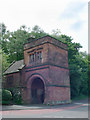
1
Bridge Carrying Kiln Lane Over The Former Churnet Valley Line
https://en.wikipedia.org/wiki/Churnet_Valley_line
Image: © Brian Deegan
Taken: 27 Feb 2021
0.04 miles
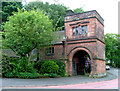
2
Railway Bridge
Bridge over the old Churnet valley railway to Rudyard, situated in the middle of Leek.
Image: © charles c
Taken: 20 May 2007
0.06 miles
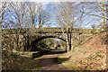
3

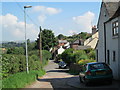
Path to Leek
Nearing Leek on the path following the route of the disused railway line.
Image: © Trevor Harris
Taken: 17 Jul 2016
0.11 miles
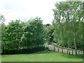
4

Countryside beside the path to Leek
The path between Rudyard and Leek follows the route of a former railway line.
Image: © Trevor Harris
Taken: 17 Jul 2016
0.15 miles
5
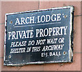
Arch Lodge Sign
That's a shame if you're getting married there and it's raining!
Image: © Neil Lewin
Taken: 1 Jun 2007
0.21 miles
6
Kiln Lane, Leek
Looking east along Kiln Lane, on bank holiday Monday afternoon. In the far distance on the left are the Staffordshire Moorlands.
Image: © David Weston
Taken: 26 Aug 2013
0.22 miles

8
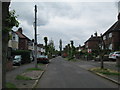
Nab Hill Avenue, Leek
Inter-war housing. There is no through-traffic; at the end, the road is linked to Hillswood Avenue, which runs parallel to this.
Image: © David Weston
Taken: 29 Jun 2013
0.23 miles