IMAGES TAKEN NEAR TO
Park Road, LEEK, ST13 8JS
Introduction
This page details the photographs taken nearby to Park Road, ST13 8JS by members of the Geograph project.
The Geograph project started in 2005 with the aim of publishing, organising and preserving representative images for every square kilometre of Great Britain, Ireland and the Isle of Man.

There are currently over 7.5m images from over14,400 individuals and you can help contribute to the project by visiting https://www.geograph.org.uk
Image Map
Images are licensed for reuse under creativecommons.org/licenses/by-sa/2.0
Notes
- Clicking on the map will re-center to the selected point.
- The higher the marker number, the further away the image location is from the centre of the postcode.
Image Listing (11 Images Found)
Images are licensed for reuse under creativecommons.org/licenses/by-sa/2.0
Image
Details
Distance
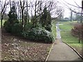
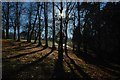
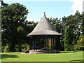
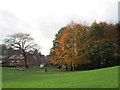
3
Autumn colours in Brough Park, Leek
Looking north from the bandstand.
Image: © David Weston
Taken: 27 Oct 2019
0.09 miles
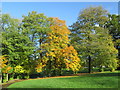
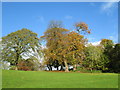
4
Brough Park - In The Woodland
Brough Park on a clear, sunny autumn day. A silhouette of the bandstand can be seen beyond the trees.
Image: © Stu JP
Taken: 16 Nov 2010
0.10 miles
8
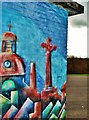
Brough Park Mural
A brightly painted "youth shelter" on the skateboard park opposite Leek Leisure Centre.
Image: © Stu JP
Taken: 17 Nov 2009
0.14 miles
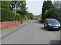
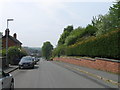
9
Brough Park, Leek
Looking towards the western edge of the park and houses beyond.
Image: © David Weston
Taken: 7 Nov 2013
0.14 miles
10
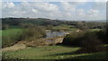
Brough Park Fields Nature Reserve, Leek
The lake is currently not shown on current Ordnance Survey maps.
Image: © Colin Park
Taken: 9 Apr 2018
0.17 miles