IMAGES TAKEN NEAR TO
Grove Terrace, LEEK, ST13 8DT
Introduction
This page details the photographs taken nearby to Grove Terrace, ST13 8DT by members of the Geograph project.
The Geograph project started in 2005 with the aim of publishing, organising and preserving representative images for every square kilometre of Great Britain, Ireland and the Isle of Man.

There are currently over 7.5m images from over14,400 individuals and you can help contribute to the project by visiting https://www.geograph.org.uk
Image Map (Loading...)


Getting Data...Please wait
Leaflet Map data © OpenStreetMap
Images are licensed for reuse under creativecommons.org/licenses/by-sa/2.0
Notes
- Clicking on the map will re-center to the selected point.
- The higher the marker number, the further away the image location is from the centre of the postcode.
Image Listing (127 Images Found)
Images are licensed for reuse under creativecommons.org/licenses/by-sa/2.0
Image
Details
Distance
1
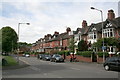
Westwood Road
A selection of middle-class terraced housing from around 1900.
Image: © Alan Murray-Rust
Taken: 16 May 2011
0.10 miles
2
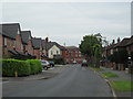
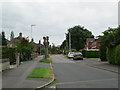
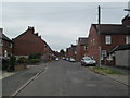
Hillswood Avenue and Frith Street, Leek
Nearest the camera is the end of Hillswood Avenue: inter-war housing on the right, recently-built houses on the left. Further along is Frith Street: terrace housing. Straight ahead, beyond the junction of Frith Street and Belle Vue Road, is a nineteenth-century commercial building which a few years ago was converted into flats.
Image: © David Weston
Taken: 2 Jul 2013
0.10 miles
3
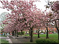
Spring in Westwood Recreation Ground, Leek
Spring blossom.
Image: © David Weston
Taken: 30 Apr 2017
0.11 miles
4
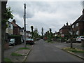
Nab Hill Avenue, Leek
Inter-war housing. There is no through-traffic; at the end, the road is linked to Hillswood Avenue, which runs parallel to this.
Image: © David Weston
Taken: 29 Jun 2013
0.11 miles
5
Hillswood Avenue, Leek
Inter-war housing on the left, more recent on the right. There is no through-traffic; at the end, the road is linked to Nab Hill Avenue, which runs parallel to this.
Image: © David Weston
Taken: 29 Jun 2013
0.11 miles
6
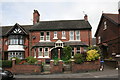
10 & 12 Westwood Road
The double porch, carrying the date 1895, is very much in the Arts and Crafts style.
Image: © Alan Murray-Rust
Taken: 16 May 2011
0.11 miles
7
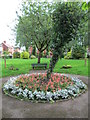
Flowers in Westwood Recreation Ground, Leek
A flower bed near the eastern end of the recreation ground.
Image: © David Weston
Taken: 23 Aug 2015
0.11 miles
8
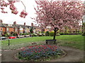
Spring in Westwood Recreation Ground, Leek
Spring blossom and flowers. The same flower bed in August 2015 is Image
Image: © David Weston
Taken: 30 Apr 2017
0.11 miles
9
Nunn Street, Leek
Looking towards Nunn Street (terrace housing) from Nab Hill Avenue (where the houses are set further back). In the distance, almost hidden by a tree, is the tower of St Edwards Church, the oldest church in Leek.
Image: © David Weston
Taken: 2 Jul 2013
0.11 miles
10
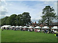
Funfair in Leek
Stalls at the fair on Westwood Recreation Ground in Leek.
Image: © David Weston
Taken: 5 Sep 2015
0.12 miles