IMAGES TAKEN NEAR TO
Grindon, LEEK, ST13 7TS
Introduction
This page details the photographs taken nearby to ST13 7TS by members of the Geograph project.
The Geograph project started in 2005 with the aim of publishing, organising and preserving representative images for every square kilometre of Great Britain, Ireland and the Isle of Man.

There are currently over 7.5m images from over14,400 individuals and you can help contribute to the project by visiting https://www.geograph.org.uk
Image Map (Loading...)


Getting Data...Please wait
Leaflet Map data © OpenStreetMap
Images are licensed for reuse under creativecommons.org/licenses/by-sa/2.0
Notes
- Clicking on the map will re-center to the selected point.
- The higher the marker number, the further away the image location is from the centre of the postcode.
Image Listing (5 Images Found)
Images are licensed for reuse under creativecommons.org/licenses/by-sa/2.0
Image
Details
Distance
1
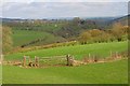
Ossoms Hill from Grindon
Ossoms Hill and the farm, Ladyside are in Image
Image: © Mick Garratt
Taken: 3 Apr 2011
0.15 miles

3
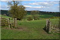
Field gate on footpath near Ossoms Hill
Image: © David Martin
Taken: 11 Apr 2014
0.22 miles
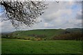
4
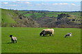
Sheep grazing near Grindon
Thor's Cave is visible in the distance on the far side of the Manifold Valley.
Image: © David Martin
Taken: 11 Apr 2014
0.23 miles