
IMAGES TAKEN NEAR TO
Blakelow Road, LEEK, ST13 7SF
Introduction
This page details the photographs taken nearby to Blakelow Road, ST13 7SF by members of the Geograph project.
The Geograph project started in 2005 with the aim of publishing, organising and preserving representative images for every square kilometre of Great Britain, Ireland and the Isle of Man.

There are currently over 7.5m images from over14,400 individuals and you can help contribute to the project by visiting https://www.geograph.org.uk
Image Map
Images are licensed for reuse under creativecommons.org/licenses/by-sa/2.0
Notes
- Clicking on the map will re-center to the selected point.
- The higher the marker number, the further away the image location is from the centre of the postcode.
Image Listing (5 Images Found)
Images are licensed for reuse under creativecommons.org/licenses/by-sa/2.0
Image
Details
Distance
1
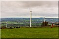
Wind turbines (with ruination) near Slate House Farm, Bradnop
Taken from the farm entrance on Blakelow Road. The three wind turbines were installed about 5-10 years ago, yet one has already reached its state of mechanical ruination and henceforth has its nacelle replaced with a sheet of tarpaulin.
Image: © Oliver Mills
Taken: 6 Nov 2021
0.06 miles
2
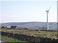
Wind turbine at Slate House Farm
The Endurance E-3120 50KW turbine was installed by LessCO2 Limited in 2012.
Image: © Ian Calderwood
Taken: 18 Apr 2015
0.06 miles
5
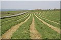
Hay field on Moorside / Morridge
Caught just after cutting, the grass has not yet lost its greenness, providing a fine contrast with the pale stubble.
Image: © Alan Murray-Rust
Taken: 3 Jun 2007
0.12 miles