IMAGES TAKEN NEAR TO
Onecote, LEEK, ST13 7RX
Introduction
This page details the photographs taken nearby to ST13 7RX by members of the Geograph project.
The Geograph project started in 2005 with the aim of publishing, organising and preserving representative images for every square kilometre of Great Britain, Ireland and the Isle of Man.

There are currently over 7.5m images from over14,400 individuals and you can help contribute to the project by visiting https://www.geograph.org.uk
Image Map (Loading...)


Getting Data...Please wait
Leaflet Map data © OpenStreetMap
Images are licensed for reuse under creativecommons.org/licenses/by-sa/2.0
Notes
- Clicking on the map will re-center to the selected point.
- The higher the marker number, the further away the image location is from the centre of the postcode.
Image Listing (4 Images Found)
Images are licensed for reuse under creativecommons.org/licenses/by-sa/2.0
Image
Details
Distance
1
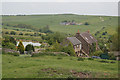
Mixon
Looking across the valley of the River Hamps to Cave Farm
Image: © Alan Murray-Rust
Taken: 3 Jun 2007
0.01 miles
2
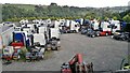
Rest home for trucks?
Some seem too young to die, but all forlorn in this isolated spot.
Image: © Chris Morgan
Taken: 22 Sep 2014
0.05 miles
3
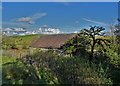
Building at Mixon's former copper mine
Image: © Neil Theasby
Taken: 28 Oct 2019
0.20 miles
4
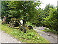
Well protected homestead
I came round the corner, saw this anti-aircraft gun; I put my hands up straightaway, before anyone could say "Stick em up".
Image: © Peter Barr
Taken: 20 Jul 2011
0.23 miles