IMAGES TAKEN NEAR TO
The Casey, LEEK, ST13 7QX
Introduction
This page details the photographs taken nearby to The Casey, ST13 7QX by members of the Geograph project.
The Geograph project started in 2005 with the aim of publishing, organising and preserving representative images for every square kilometre of Great Britain, Ireland and the Isle of Man.

There are currently over 7.5m images from over14,400 individuals and you can help contribute to the project by visiting https://www.geograph.org.uk
Image Map
Images are licensed for reuse under creativecommons.org/licenses/by-sa/2.0
Notes
- Clicking on the map will re-center to the selected point.
- The higher the marker number, the further away the image location is from the centre of the postcode.
Image Listing (4 Images Found)
Images are licensed for reuse under creativecommons.org/licenses/by-sa/2.0
Image
Details
Distance
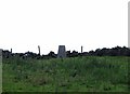
3
Black Heath Ordnance Survey Trig Pillar
With masts behind.
Image: © Siobhan Brennan-Raymond
Taken: 7 Mar 2013
0.23 miles
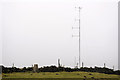
4
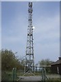
Mast
This is one of four masts on Ipstones Edge which don't exactly beautify the place.
Image: © Ian Calderwood
Taken: 29 Apr 2007
0.24 miles