IMAGES TAKEN NEAR TO
Bradnop, LEEK, ST13 7NX
Introduction
This page details the photographs taken nearby to ST13 7NX by members of the Geograph project.
The Geograph project started in 2005 with the aim of publishing, organising and preserving representative images for every square kilometre of Great Britain, Ireland and the Isle of Man.

There are currently over 7.5m images from over14,400 individuals and you can help contribute to the project by visiting https://www.geograph.org.uk
Image Map
Images are licensed for reuse under creativecommons.org/licenses/by-sa/2.0
Notes
- Clicking on the map will re-center to the selected point.
- The higher the marker number, the further away the image location is from the centre of the postcode.
Image Listing (48 Images Found)
Images are licensed for reuse under creativecommons.org/licenses/by-sa/2.0
Image
Details
Distance
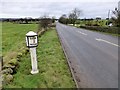
3
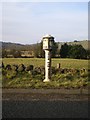
The Morridge Side milepost - detail
One of a number of cast-iron mileposts along the A523, embossed with the maker's details (James Bassett Ashborne 1834) on the top.
Image: © Richard Law
Taken: 4 Mar 2010
0.10 miles
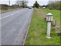
4
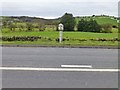
Milepost beside the A523
12 miles from Ashbourne, 3 from Leek
Grade II listed:
Name: MILE POST 20 METRES SOUTH OF COOKS LANE
List entry Number: 1038223
https://historicengland.org.uk/listing/the-list/list-entry/1038223
Image: © David Lally
Taken: 29 Jan 2013
0.10 miles
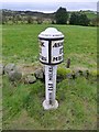
5
Milepost beside the A523
12 miles from Ashbourne, 3 from Leek
Grade II listed:
Name: MILE POST 20 METRES SOUTH OF COOKS LANE
List entry Number: 1038223
https://historicengland.org.uk/listing/the-list/list-entry/1038223
Image: © David Lally
Taken: 29 Jan 2013
0.10 miles
6
Milepost beside the A523
12 miles from Ashbourne, 3 from Leek
Grade II listed:
Name: MILE POST 20 METRES SOUTH OF COOKS LANE
List entry Number: 1038223
https://historicengland.org.uk/listing/the-list/list-entry/1038223
Image: © David Lally
Taken: 29 Jan 2013
0.10 miles
7
Milepost beside the A523
12 miles from Ashbourne, 3 from Leek
Grade II listed:
Name: MILE POST 20 METRES SOUTH OF COOKS LANE
List entry Number: 1038223
https://historicengland.org.uk/listing/the-list/list-entry/1038223
Image: © David Lally
Taken: 29 Jan 2013
0.10 miles
8
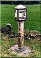
Old Milepost by the A523, Morridge Side, Bradnop Parish
Cast iron post by the A523, in parish of BRADNOP (STAFFORDSHIRE MOORLANDS District), Morridge Side, 20m South of Cook's Lane, on grass in front of drystone wall, on South West side of road. Ashbourne iron bobbin, erected by the Ashbourne to Leek & Congleton turnpike trust in the 19th century.
Inscription reads:-
: LEEK / 3 / MILES. : : ASHBN. / 12 / MILES. :
Maker:-
: JAMES BASSETT ASHBOURNE 1834. :
Grade II listed. List Entry Number: 1038223
https://historicengland.org.uk/listing/the-list/list-entry/1038223
Milestone Society National ID: ST_LKAB03.
Image: © J Higgins
Taken: 1 Jan 2000
0.10 miles
9
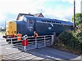
Apesford Crossing restored to use
Apesford Crossing is on the Leekbrook Junction to Cauldon Lowe line which was being restored to use in 2010. In October, 37075 was being used for driver training, in preparation for the reopening gala in November.
Image: © Ian Calderwood
Taken: 16 Oct 2010
0.11 miles
10
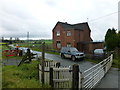
Level crossing near Apesford
This is on the Cauldon Lowe Branch railway
Image: © Raymond Knapman
Taken: 8 Oct 2017
0.11 miles