IMAGES TAKEN NEAR TO
Bradnop, LEEK, ST13 7NU
Introduction
This page details the photographs taken nearby to ST13 7NU by members of the Geograph project.
The Geograph project started in 2005 with the aim of publishing, organising and preserving representative images for every square kilometre of Great Britain, Ireland and the Isle of Man.

There are currently over 7.5m images from over14,400 individuals and you can help contribute to the project by visiting https://www.geograph.org.uk
Image Map (Loading...)


Getting Data...Please wait
Leaflet Map data © OpenStreetMap
Images are licensed for reuse under creativecommons.org/licenses/by-sa/2.0
Notes
- Clicking on the map will re-center to the selected point.
- The higher the marker number, the further away the image location is from the centre of the postcode.
Image Listing (5 Images Found)
Images are licensed for reuse under creativecommons.org/licenses/by-sa/2.0
Image
Details
Distance
1

Farm building near Bradnop
Seen from a lay-by on the A523 not far from Leek, an isolated farm building. The higher ground beyond is Morridge.
Image: © David Weston
Taken: 30 Jul 2016
0.08 miles
2
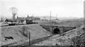
Bradnop Station (remains)
View NW, towards Leek Brook Junction and Leek; ex-NSR Leek - Waterhouses branch. Bradnop station was closed to passengers when the branch service was withdrawn on 30/9/35, but it remained open for goods until 4/5/64 when all except stone traffic for the railway ceased Caldon Quarry - Leek Brook Junction, Caldon Junction - Waterhouses having closed 1/3/43; in turn stone traffic ceased in 1989.
Image: © Ben Brooksbank
Taken: 20 Apr 1962
0.18 miles
3
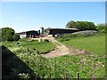
Longshaw Farm
Seen from a train on the Churnet Valley Railway's Cauldon Lowe branch.
Image: © Christine Johnstone
Taken: 27 May 2012
0.21 miles
4
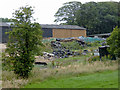
Farm buildings near Bradnop, Staffordshire
This view of buildings and the yard at Longshaw farm was taken from a passing railway train.
Image: © Roger D Kidd
Taken: 1 Aug 2015
0.21 miles
5
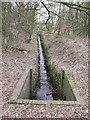
Drain under the railway
This drainage channel feeds water into a culvert that runs under the railway line to Cauldon Low.
Image: © Ian Calderwood
Taken: 24 Feb 2013
0.23 miles