IMAGES TAKEN NEAR TO
Martinslow Lane, LEEK, ST13 7GA
Introduction
This page details the photographs taken nearby to Martinslow Lane, ST13 7GA by members of the Geograph project.
The Geograph project started in 2005 with the aim of publishing, organising and preserving representative images for every square kilometre of Great Britain, Ireland and the Isle of Man.

There are currently over 7.5m images from over14,400 individuals and you can help contribute to the project by visiting https://www.geograph.org.uk
Image Map (Loading...)


Getting Data...Please wait
Leaflet Map data © OpenStreetMap
Images are licensed for reuse under creativecommons.org/licenses/by-sa/2.0
Notes
- Clicking on the map will re-center to the selected point.
- The higher the marker number, the further away the image location is from the centre of the postcode.
Image Listing (5 Images Found)
Images are licensed for reuse under creativecommons.org/licenses/by-sa/2.0
Image
Details
Distance
1
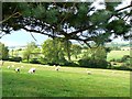
Sheep on a slope
Sheep grazing near Martin's Low.
Image: © James Allan
Taken: 24 Aug 2008
0.05 miles
3
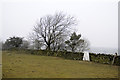
Martins Low Ordnance Survey Trig Pillar
Image: © Siobhan Brennan-Raymond
Taken: 7 Mar 2013
0.14 miles
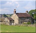
4
On Martin's Low
Near Martinslow Farm. To the right a footpath heads off down to the River Hamps.
Image: © Trevor Harris
Taken: 1 Sep 2021
0.18 miles
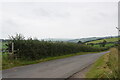
5
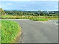
Three-way junction
Looking from the road coming from Grindon Moor to the roads heading right towards Waterfall Cross and left towards Waterfall village. The white buildings to the right of the signpost are the Lafarge cement plant at Cauldon Image
Image: © James Allan
Taken: 24 Aug 2008
0.23 miles