IMAGES TAKEN NEAR TO
Basford Bridge Terrace, LEEK, ST13 7EG
Introduction
This page details the photographs taken nearby to Basford Bridge Terrace, ST13 7EG by members of the Geograph project.
The Geograph project started in 2005 with the aim of publishing, organising and preserving representative images for every square kilometre of Great Britain, Ireland and the Isle of Man.

There are currently over 7.5m images from over14,400 individuals and you can help contribute to the project by visiting https://www.geograph.org.uk
Image Map
Images are licensed for reuse under creativecommons.org/licenses/by-sa/2.0
Notes
- Clicking on the map will re-center to the selected point.
- The higher the marker number, the further away the image location is from the centre of the postcode.
Image Listing (226 Images Found)
Images are licensed for reuse under creativecommons.org/licenses/by-sa/2.0
Image
Details
Distance
1
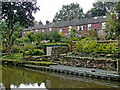
Terraced housing in Cheddleton, Staffordshire
This is Basford Bridge Terrace by the Caldon Canal in Cheddleton.
Image: © Roger Kidd
Taken: 2 Sep 2009
0.00 miles
2
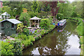
Basford Bridge Terrace at Cheddleton, Staffordshire
This fine terrace overlooks the Caldon Canal.
Image: © Roger D Kidd
Taken: 28 May 2011
0.01 miles
3
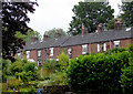
Terraced housing in Cheddleton, Staffordshire
The canal-side buildings comprising Basford Bridge Terrace are well restored and maintained.
Image: © Roger D Kidd
Taken: 1 Aug 2015
0.01 miles
4
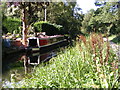
Echo Mooring
The view near Basford Bridge on the Caldon Canal at Cheddleton.
Image: © Gordon Griffiths
Taken: 12 Sep 2018
0.02 miles
5
Caldon Canal, Cheddleton
The canal passes the bottoms of gardens near Basford Bridge.
Image: © Stephen McKay
Taken: 17 May 2023
0.02 miles
6
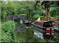
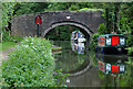
Caldon Canal at Cheddleton, Staffordshire
The image includes Basford (canal) Bridge No 44, and a pub sign announcing The Boat Inn which is on the right beyond the bridge. There are private moorings on the right, and plenty of moorings for visitors on the towpath side.
The Caldon Branch of the Trent and Mersey Canal opened in 1779. It runs eighteen miles from Etruria in Stoke-on-Trent, where it leaves the Trent and Mersey Canal. It terminates at Froghall about five miles south-east of Cheddleton. The canal has seventeen locks and the 69 metre long very low Froghall Tunnel, unusable by many narrowboats. The canal did originally continue through to Uttoxeter, but the section beyond Froghall was closed by the late 1840s, much of its course being filled in to construct a railway.
Image: © Roger D Kidd
Taken: 28 May 2011
0.02 miles
7
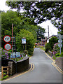
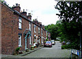
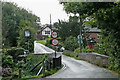
Basfordbridge Lane in Cheddleton, Staffordshire
Basford Bridge crosses the River Churnet behind the camera. The bridge in the foreground here crosses the Caldon Canal.
Image: © Roger D Kidd
Taken: 1 Aug 2015
0.02 miles
8
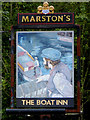
Boat Inn pub sign in Cheddleton, Staffordshire
The public house is by the Caldon Canal near Basford Bridge.
Image]
Image: © Roger D Kidd
Taken: 1 Aug 2015
0.02 miles
9
Basfordbridge Lane crossing the canal in Cheddleton, Staffordshire
Looking east, Basfordbridge Lane crosses the Caldon Canal here in Cheddleton.
Image: © Roger Kidd
Taken: 3 Sep 2009
0.02 miles
10
Caldon Canal at Cheddleton, Staffordshire
The image includes Basford (canal) Bridge No 44, and a pub sign announcing The Boat Inn which is on the right beyond the bridge.
The Caldon Branch of the Trent and Mersey Canal opened in 1779. It runs eighteen miles from Etruria in Stoke-on-Trent, where it leaves the Trent and Mersey Canal. It terminates at Froghall about five miles south-east of Cheddleton. The canal has seventeen locks and the 69 metre long very low Froghall Tunnel, unusable by many narrowboats. The canal did originally continue through to Uttoxeter, but the section beyond Froghall was closed by the late 1840s, much of its course being filled in to construct a railway.
Image: © Roger D Kidd
Taken: 28 May 2011
0.02 miles