IMAGES TAKEN NEAR TO
Cheadle Road, LEEK, ST13 7DP
Introduction
This page details the photographs taken nearby to Cheadle Road, ST13 7DP by members of the Geograph project.
The Geograph project started in 2005 with the aim of publishing, organising and preserving representative images for every square kilometre of Great Britain, Ireland and the Isle of Man.

There are currently over 7.5m images from over14,400 individuals and you can help contribute to the project by visiting https://www.geograph.org.uk
Image Map
Images are licensed for reuse under creativecommons.org/licenses/by-sa/2.0
Notes
- Clicking on the map will re-center to the selected point.
- The higher the marker number, the further away the image location is from the centre of the postcode.
Image Listing (18 Images Found)
Images are licensed for reuse under creativecommons.org/licenses/by-sa/2.0
Image
Details
Distance
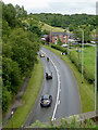
1
Sheephouse Farm
The farm is on the A520. Viewed from a train on the Churnet Valley Railway.
Image: © Stephen Craven
Taken: 28 Dec 2011
0.01 miles
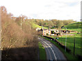
2
Pasture by Cheadle Road south of Leek, Staffordshire
The A520 is seen here from the Cauldon Lowe branch railway line currently owned by the Moorland and City Railways Company, which has plans to reopen lines as far as Leek and Stoke. The Churnet Valley Railway still operates intermittent steam hauled trains as far as the former Ipstones Station.
Image: © Roger D Kidd
Taken: 1 Aug 2015
0.04 miles
3
Bend on the A520 near Sheephouse Farm
Seen from a train on the Churnet Valley Railway's Cauldon Lowe branch.
Image: © Christine Johnstone
Taken: 27 May 2012
0.04 miles
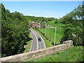
4
Cheadle Road south of Leek, Staffordshire
Seen from a passing Churnet Valley Railways train on its way from Ipstones to Froghall. Looking towards Leek.
Image: © Roger D Kidd
Taken: 1 Aug 2015
0.04 miles
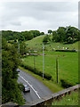
5

Grazing south of Leek, Staffordshire
The cattle are grazing on the hillside by Sheephouse Farm, and are seen here from a passing railway train west of the bridge.
Image: © Roger D Kidd
Taken: 1 Aug 2015
0.06 miles
6

Grazing south of Leek, Staffordshire
The cattle are grazing on the hillside by Sheephouse Farm, and are seen here from a passing railway train west of the bridge.
Image: © Roger D Kidd
Taken: 1 Aug 2015
0.06 miles
7
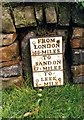
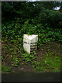
Old Milestone by the A520, Cheddleton Road, Leek
Metal plate attached to stone post by the A520, in parish of LEEK (STAFFORDSHIRE MOORLANDS District), Cheddleton Road, Sheephouse Farm, set in stone wall, on East side of road. Sandon iron plate, erected by the Sandon, Hugbridge, Hilderstone, Bullock Smithy turnpike trust in the 19th century.
Inscription reads:-
: FROM / LONDON / 153.MILES / - / TO / SANDON / 17 . MILES / - / TO / LEEK / 1 . MILE :
Grade II listed.
List Entry Number: 1268643 https://historicengland.org.uk/listing/the-list/list-entry/1268643
Milestone Society National ID: ST_STLK22A.
Image: © J Higgins
Taken: 1 Jan 2000
0.07 miles
8
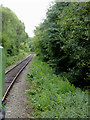
Railway line at Leekbrook, Staffordshire
Looking towards Caldon Lowe. On one weekend each month, trains still go as far as Ipstones Loop. Originally the line was built to transport stone of the quarries at Caldon Lowe.
The preserved Churnet Valley Railway operates steam and diesel (sometimes both!) locomotives to haul trains between Kingsley and Froghall Station to Cheddleton, and sometimes beyond to Ipstones. https://www.churnet-valley-railway.co.uk/
Image: © Roger D Kidd
Taken: 1 Aug 2015
0.10 miles
10
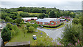
Light industry by Cheadle Road near Leek, Staffordshire
The Esterchem chemicals works is on the corner, seen from a passing train on the bridge.
Image: © Roger D Kidd
Taken: 1 Aug 2015
0.13 miles