IMAGES TAKEN NEAR TO
Priory Avenue, LEEK, ST13 6QJ
Introduction
This page details the photographs taken nearby to Priory Avenue, ST13 6QJ by members of the Geograph project.
The Geograph project started in 2005 with the aim of publishing, organising and preserving representative images for every square kilometre of Great Britain, Ireland and the Isle of Man.

There are currently over 7.5m images from over14,400 individuals and you can help contribute to the project by visiting https://www.geograph.org.uk
Image Map (Loading...)


Getting Data...Please wait
Leaflet Map data © OpenStreetMap
Images are licensed for reuse under creativecommons.org/licenses/by-sa/2.0
Notes
- Clicking on the map will re-center to the selected point.
- The higher the marker number, the further away the image location is from the centre of the postcode.
Image Listing (12 Images Found)
Images are licensed for reuse under creativecommons.org/licenses/by-sa/2.0
Image
Details
Distance
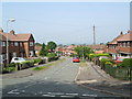
2
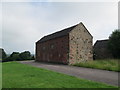
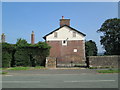
Old building near Haregate Road, Leek
North-eastern edge of Leek. This building (seen here from the south-west), which has stone end-walls and brick side-walls, was perhaps built as a barn a long time ago; comparatively recently it was converted into garages. The doors are on the other side. There are weeds in front of the garage doors, so it seems to be no longer in use. On the right of the photo is another disused building, probably once a farm building. Haregate Road is behind the camera.
Image: © David Weston
Taken: 10 Jul 2013
0.09 miles
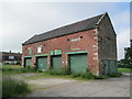
3
Old building near Haregate Road, Leek
The same view, taken in July 2013, is Image A new road, Osprey Close, has been built by the old barn, and houses have been built nearby. The other stone building, on the right and partly hidden, is Haregate Hall.
Image: © David Weston
Taken: 20 Dec 2015
0.09 miles
4
Old building near Haregate Road, Leek
North-eastern edge of Leek. This building (seen here from the north-east), which has stone end-walls and brick side-walls, was perhaps built as a barn a long time ago; comparatively recently it was converted into garages. There are weeds in front of the garage doors, so it seems to be no longer in use. Haregate Road is in front of the houses seen on the left.
Image: © David Weston
Taken: 10 Jul 2013
0.09 miles
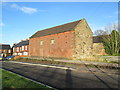
5
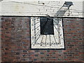
Sundial on disused building, Haregate Road, Leek
Sundial on a building with boarded-up windows, near to disused farm buildings, on the edge of north-eastern residential area of Leek.
Image: © David Weston
Taken: 12 Jul 2013
0.10 miles
6
Disused building with sundial, Haregate Road, Leek
On Haregate Road at the junction with Queens Drive. There is a sundial on the wall of this building with boarded-up windows, near to disused farm buildings. This is on the edge of the residential area north-east of the town centre.
Image: © David Weston
Taken: 12 Jul 2013
0.10 miles
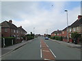
7
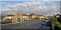
Haregate Road, Leek
North-east of the town centre. Looking north-east along Haregate Road.
Image: © David Weston
Taken: 10 Jul 2013
0.10 miles
8
War Memorial and park at Ball Haye Green
Image: © Chris Morgan
Taken: 5 Dec 2012
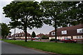
0.17 miles
9
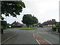
Princess Avenue, Leek
Residential area north-east of the town centre. Looking along Princess Avenue, from the junction with Windsor Drive.
Image: © David Weston
Taken: 12 Jul 2013
0.17 miles
10
Haregate Road, Leek
Residential area north-east of the town centre. Looking south-west along Haregate Road towards Ball Haye Green, where there is terrace housing in the distance.
Image: © David Weston
Taken: 10 Jul 2013
0.23 miles