IMAGES TAKEN NEAR TO
Westwinds Close, LEEK, ST13 5SQ
Introduction
This page details the photographs taken nearby to Westwinds Close, ST13 5SQ by members of the Geograph project.
The Geograph project started in 2005 with the aim of publishing, organising and preserving representative images for every square kilometre of Great Britain, Ireland and the Isle of Man.

There are currently over 7.5m images from over14,400 individuals and you can help contribute to the project by visiting https://www.geograph.org.uk
Image Map
Images are licensed for reuse under creativecommons.org/licenses/by-sa/2.0
Notes
- Clicking on the map will re-center to the selected point.
- The higher the marker number, the further away the image location is from the centre of the postcode.
Image Listing (6 Images Found)
Images are licensed for reuse under creativecommons.org/licenses/by-sa/2.0
Image
Details
Distance
1
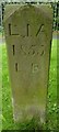
Old Boundary Marker by the A520, Cheddleton Road
Parish Boundary Marker by the A520, in parish of Leek (Staffordshire Moorlands District), Cheddleton Road, West side, on grass next to the listed plague stone Image
Inscription reads:-
L.I.A
1855
L.B
(Leek Improvement Act)
Grade II listed by Historic England.
List Entry Number: 1268640 https://historicengland.org.uk/listing/the-list/list-entry/1268640
Surveyed
Milestone Society National ID: ST_LEE01pb
Image: © M Bardell
Taken: Unknown
0.08 miles
2
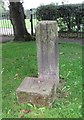
Old Wayside Cross by the A520, Cheddleton Road, Leek
Plague Stone, old shaft by the A520), in parish of Leek (Staffordshire Moorlands District), Cheddleton Road, moved from Image
Grade II listed.
List Entry Number: 1268644 https://historicengland.org.uk/listing/the-list/list-entry/1268644
To be surveyed
Milestone Society National ID: STMO_LEK01
Image: © C Mayer
Taken: 13 Sep 2018
0.08 miles
3
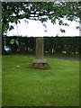
The Leek plague stone
This is the broken stump of a medieval roadside cross, known locally as The Plague Stone. It is thought that provisions were left on or near the cross for the townspeople of Leek during the Bubonic Plague, and payment was left by the people in bowls of vinegar, to prevent spread of the disease.
Image: © Richard Law
Taken: 15 Sep 2009
0.09 miles
5
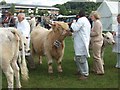
The Leek Show
The show took place in July 2007 just before the foot & mouth crisis stopped movements of animals around the country.
Image: © Martyn Davies
Taken: 28 Jul 2007
0.23 miles
6
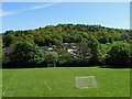
Ballington Wood
The view over All Saints' School playing field and Cheadle Road Allotments to Ballington Wood.
Image: © Ian Calderwood
Taken: 7 May 2017
0.24 miles