IMAGES TAKEN NEAR TO
Newcastle Road, LEEK, ST13 5RX
Introduction
This page details the photographs taken nearby to Newcastle Road, ST13 5RX by members of the Geograph project.
The Geograph project started in 2005 with the aim of publishing, organising and preserving representative images for every square kilometre of Great Britain, Ireland and the Isle of Man.

There are currently over 7.5m images from over14,400 individuals and you can help contribute to the project by visiting https://www.geograph.org.uk
Image Map (28 Images)


Getting Data...Please wait
Leaflet Map data © OpenStreetMap
Images are licensed for reuse under creativecommons.org/licenses/by-sa/2.0
Notes
- Clicking on the map will re-center to the selected point.
- The higher the marker number, the further away the image location is from the centre of the postcode.
Image Listing (28 Images Found)
Images are licensed for reuse under creativecommons.org/licenses/by-sa/2.0
Image
Details
Distance
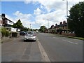
2
Newcastle Road
The view of the A53 in Leek, Staffordshire.
Image: © Gordon Griffiths
Taken: 14 Sep 2018
0.03 miles
4
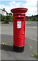
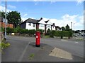
Elizabeth II postbox on Newcastle Road, Leek
Postbox No. ST13 709.
See Image] for context.
Image: © JThomas
Taken: 5 Jul 2024
0.04 miles
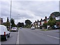
5
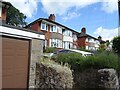
Houses on Newcastle Road, Leek
Showing position of Postbox No. ST13 709.
See Image] for postbox.
Image: © JThomas
Taken: 5 Jul 2024
0.05 miles
7

Leek railway station
An enthusiasts' special train at about the time of closure
Image: © Flying Stag
Taken: Unknown
0.13 miles
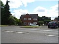
8

Barnfields Close
Taken from the bridge over the former railway. The large building on the right is a Morrisons supermarket which has been built over the railway route.
Image: © David Martin
Taken: 6 Aug 2022
0.14 miles
9
Old Disused Rail Line Becomes Road, Leek
Image: © Brian Deegan
Taken: 21 Mar 2020
0.14 miles
10

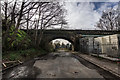
Leek railway station (site), Staffordshire
Opened in 1849 by the North Staffordshire Railway on the line from Uttoxeter to Macclesfield, this station closed to passengers 1965 and completely in 1970 . It was demolished in 1973 and the site became a supermarket.
View southeast towards Leek Brook and Uttoxeter. The two parallel platforms were in the immediate foreground and the main building was to the left. The road bridge over the former railway tracks was still extant when this image was taken, and is where the camera is positioned.
The heritage Churnet Valley Railway extended northwards to the outskirts of Leek in 2024 but were prevented from reaching the original station site by the existence of the supermarket.
Image: © Nigel Thompson
Taken: 26 Apr 2025
0.15 miles