IMAGES TAKEN NEAR TO
Sandon Street, LEEK, ST13 5QR
Introduction
This page details the photographs taken nearby to Sandon Street, ST13 5QR by members of the Geograph project.
The Geograph project started in 2005 with the aim of publishing, organising and preserving representative images for every square kilometre of Great Britain, Ireland and the Isle of Man.

There are currently over 7.5m images from over14,400 individuals and you can help contribute to the project by visiting https://www.geograph.org.uk
Image Map
Images are licensed for reuse under creativecommons.org/licenses/by-sa/2.0
Notes
- Clicking on the map will re-center to the selected point.
- The higher the marker number, the further away the image location is from the centre of the postcode.
Image Listing (13 Images Found)
Images are licensed for reuse under creativecommons.org/licenses/by-sa/2.0
Image
Details
Distance
1
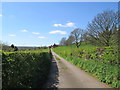
Sandon Street, Leek
Looking along a country lane from the junction with the Cheddleton Road (the A520) towards the houses of Sandon Street.
Image: © David Weston
Taken: 18 Apr 2014
0.05 miles
2
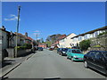
Sandon Street, Leek
Looking towards the junction with Junction Road, beyond which is Leek Cemetery.
Image: © David Weston
Taken: 18 Apr 2014
0.08 miles
4
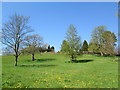
Field near Sandon Street, Leek
Looking north from the country lane which is part of Sandon Street.
Image: © David Weston
Taken: 18 Apr 2014
0.13 miles
5
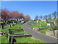
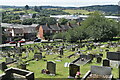
Leek Cemetery
Trees are beginning to blossom.
Image: © David Weston
Taken: 18 Apr 2014
0.13 miles
6
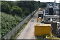
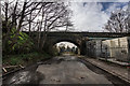
Former railway line beside industrial estate
The railway trackbed is now an access roadway. A footpath follows the same course just outside the fence.
Image: © David Martin
Taken: 6 Aug 2022
0.16 miles
7
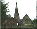
Leek Cemetery
This is the chapel at Leek Cemetery with its quite splendid spire. The wall on the left encloses a small garden of remembrance.
Image: © Neil Lewin
Taken: 25 Aug 2006
0.19 miles
8
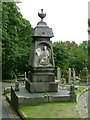
A fine memorial
Situated in Leek Cemetery, even with the damage to the base this is still a proud memorial.
Image: © Neil Lewin
Taken: 25 Aug 2006
0.19 miles
9
Old Disused Rail Line Becomes Road, Leek
Image: © Brian Deegan
Taken: 21 Mar 2020
0.19 miles
10

Barnfields Close
Taken from the bridge over the former railway. The large building on the right is a Morrisons supermarket which has been built over the railway route.
Image: © David Martin
Taken: 6 Aug 2022
0.21 miles