IMAGES TAKEN NEAR TO
Broad Street, LEEK, ST13 5QA
Introduction
This page details the photographs taken nearby to Broad Street, ST13 5QA by members of the Geograph project.
The Geograph project started in 2005 with the aim of publishing, organising and preserving representative images for every square kilometre of Great Britain, Ireland and the Isle of Man.

There are currently over 7.5m images from over14,400 individuals and you can help contribute to the project by visiting https://www.geograph.org.uk
Image Map
Images are licensed for reuse under creativecommons.org/licenses/by-sa/2.0
Notes
- Clicking on the map will re-center to the selected point.
- The higher the marker number, the further away the image location is from the centre of the postcode.
Image Listing (55 Images Found)
Images are licensed for reuse under creativecommons.org/licenses/by-sa/2.0
Image
Details
Distance
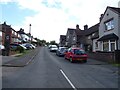
1
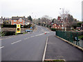
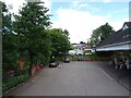
The A53 Newcastle Road by Morrisons' store
Looking along Newcastle Road towards its junction with Burton Street on the left, Junction Street on the right, and Broad Street straight on. Morrisons' store is on the right Image but their petrol station is on the left - both are joined under this main road by a road along the former railway track.
Image: © John S Turner
Taken: 12 Mar 2012
0.03 miles
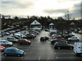
2
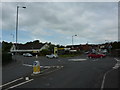
Roundabout at Woodcroft
On the south west side of the town, on the A53 road,part of the Morrisons supermarket.
Image: © Peter Barr
Taken: 29 May 2013
0.03 miles
6
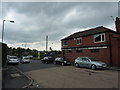
Morrisons' store, Leek
Originally belonging to Safeway's, this became Morrisons when they bought out the company.
Image: © Jonathan Kington
Taken: 10 Dec 2009
0.06 miles
8
Leek Former Railway Station, Now a Morrisons Car Park
Leek had a substantial station and goods yard, but competition from road transport led to the withdrawal of services to Stoke-on-Trent in 1956 and the remaining passenger services to Uttoxeter in 1965. Freight workings continued until 1970.
The site of the station is now occupied by a Morrisons supermarket, although the road bridge is still in situ between the car park and petrol station.
https://en.wikipedia.org/wiki/Leek_railway_station
Image: © Brian Deegan
Taken: 21 Mar 2020
0.07 miles
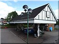
9
Supermarket service station, Leek
On the site of a former railway.
Image: © JThomas
Taken: 5 Jul 2024
0.07 miles
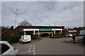
10
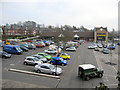
Morrisons' car park and store
Looking down on Morrisons' car park from the A53. Formerly, the area was Leek station and goods yard, and it is interesting to see how even the modern building has changed since 2009: Image
Image: © John S Turner
Taken: 12 Mar 2012
0.07 miles