IMAGES TAKEN NEAR TO
Whitfield Street, LEEK, ST13 5PH
Introduction
This page details the photographs taken nearby to Whitfield Street, ST13 5PH by members of the Geograph project.
The Geograph project started in 2005 with the aim of publishing, organising and preserving representative images for every square kilometre of Great Britain, Ireland and the Isle of Man.

There are currently over 7.5m images from over14,400 individuals and you can help contribute to the project by visiting https://www.geograph.org.uk
Image Map
Images are licensed for reuse under creativecommons.org/licenses/by-sa/2.0
Notes
- Clicking on the map will re-center to the selected point.
- The higher the marker number, the further away the image location is from the centre of the postcode.
Image Listing (55 Images Found)
Images are licensed for reuse under creativecommons.org/licenses/by-sa/2.0
Image
Details
Distance
3
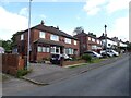
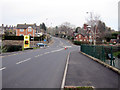
Cherry blossom time, Selborne Road, Leek
Housing estate on the south side of the town, with some building work, beyond the roundabout, which looks like it has been suspended.
Image: © Peter Barr
Taken: 29 May 2013
0.10 miles
4
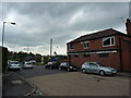
Morrisons' store, Leek
Originally belonging to Safeway's, this became Morrisons when they bought out the company.
Image: © Jonathan Kington
Taken: 10 Dec 2009
0.11 miles
5
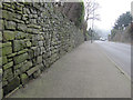
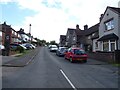
Broad Street and a bench mark
Looking south-west along Broad Street with a bench mark cut into the stone wall on the left: Image
Image: © John S Turner
Taken: 12 Mar 2012
0.11 miles
6
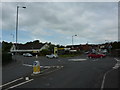
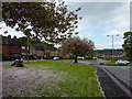
Roundabout at Woodcroft
On the south west side of the town, on the A53 road,part of the Morrisons supermarket.
Image: © Peter Barr
Taken: 29 May 2013
0.11 miles
7
The A53 Newcastle Road by Morrisons' store
Looking along Newcastle Road towards its junction with Burton Street on the left, Junction Street on the right, and Broad Street straight on. Morrisons' store is on the right Image but their petrol station is on the left - both are joined under this main road by a road along the former railway track.
Image: © John S Turner
Taken: 12 Mar 2012
0.11 miles
8
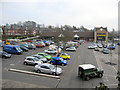
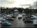
Morrisons' car park and store
Looking down on Morrisons' car park from the A53. Formerly, the area was Leek station and goods yard, and it is interesting to see how even the modern building has changed since 2009: Image
Image: © John S Turner
Taken: 12 Mar 2012
0.12 miles
9
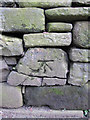
Bench mark in Broad Street
Image: © John S Turner
Taken: 12 Mar 2012
0.12 miles