IMAGES TAKEN NEAR TO
Sharron Drive, LEEK, ST13 5BT
Introduction
This page details the photographs taken nearby to Sharron Drive, ST13 5BT by members of the Geograph project.
The Geograph project started in 2005 with the aim of publishing, organising and preserving representative images for every square kilometre of Great Britain, Ireland and the Isle of Man.

There are currently over 7.5m images from over14,400 individuals and you can help contribute to the project by visiting https://www.geograph.org.uk
Image Map (Loading...)


Getting Data...Please wait
Leaflet Map data © OpenStreetMap
Images are licensed for reuse under creativecommons.org/licenses/by-sa/2.0
Notes
- Clicking on the map will re-center to the selected point.
- The higher the marker number, the further away the image location is from the centre of the postcode.
Image Listing (22 Images Found)
Images are licensed for reuse under creativecommons.org/licenses/by-sa/2.0
Image
Details
Distance
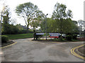
1
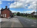
Leek Entrance Sign
Dwellings and A523 Road looking in the direction of the hospital and town centre.
Image: © Jonathan Clitheroe
Taken: 11 Aug 2023
0.06 miles
2
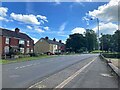
Dwellings on the outskirts of Leek
Looking away from the town along the A523 Road.
Image: © Jonathan Clitheroe
Taken: 11 Aug 2023
0.07 miles
3
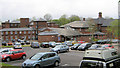
Staffordshire Moorlands Hospital
A community hospital in Leek, with a great reputation and a long waiting list, that serves the Staffordshire Moorlands. They have a minor injuries clinic, rehabilitation wards and various other services.
Image: © Jonathan Kington
Taken: 5 May 2010
0.08 miles
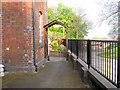
5
Moorlands Hospital car park
This is the car park for the Image Unusually for an NHS hospital car park it is actually free!
Image: © Jonathan Kington
Taken: 12 May 2010
0.10 miles
6
Entrance to the Moorland Garden
Image: © Jonathan Kington
Taken: 12 May 2010
0.12 miles
7
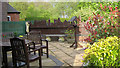
The Moorland Garden
Tucked in a corner of the Image is this lovely little garden, it was built in 2003 using money donated by the people of Leek. The brown fence in the background is cut and carved in a way that depicts some of the prominent buildings in the town.
Image: © Jonathan Kington
Taken: 12 May 2010
0.12 miles
8
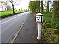
Leek, milepost
One of a distinctive series of "bobbin" style mileposts between Leek and Ashbourne; this one is on A523, and shows distances to Leek (1), Ashbourne (14) and London (153). Listed by English Heritage: http://www.imagesofengland.org.uk/Details/default.aspx?pid=2&id=461588
Image: © Mike Faherty
Taken: 10 May 2012
0.13 miles
9
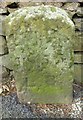
Old Boundary Marker by the A523, Ashbourne Road, Leek parish
Parish Boundary Marker by the A523, in parish of Leek (Staffordshire Moorlands District), Ashbourne Road, in pavement, back to low stone wall. The Stone refers to the 'Leek Improvement Act' of 1855 - see listing.
Inscription reads:-
LIA
1855
L.B.
Grade II listed.
List Entry Number: 1268662 https://historicengland.org.uk/listing/the-list/list-entry/1268662
Surveyed
Milestone Society National ID: ST_LEE03pb
Image: © Milestone Society
Taken: Unknown
0.13 miles
10
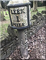
Old Milepost by the A523, Ashbourne Road, Leek
Cast iron post by the A523, in parish of Leek (Staffordshire Moorlands District), between Padwick Farm and Leek, 50m South of junction with Mount Road, in tarmac in front of drystone wall, on West side of road. Ashbourne iron bobbin, erected by the Ashbourne to Leek & Congleton turnpike trust in the 19th century. An earlier photograph can be found here https://www.geograph.org.uk/photo/6072861.
Inscription reads:-
LEEK / 1 / MILE. : : LONDON 153 MILES : : ASHBN.. / 14 / MILES. :
Maker:-
: JAMES BASSETT ASHBOURNE 1834.
Grade II listed.
List Entry Number: 1268664 https://historicengland.org.uk/listing/the-list/list-entry/1268664
Milestone Society National ID: ST_LKAB01
Image: © Ian King
Taken: 17 Feb 2023
0.14 miles