IMAGES TAKEN NEAR TO
Uttoxeter Road, STOKE-ON-TRENT, ST11 9JG
Introduction
This page details the photographs taken nearby to Uttoxeter Road, ST11 9JG by members of the Geograph project.
The Geograph project started in 2005 with the aim of publishing, organising and preserving representative images for every square kilometre of Great Britain, Ireland and the Isle of Man.

There are currently over 7.5m images from over14,400 individuals and you can help contribute to the project by visiting https://www.geograph.org.uk
Image Map
Images are licensed for reuse under creativecommons.org/licenses/by-sa/2.0
Notes
- Clicking on the map will re-center to the selected point.
- The higher the marker number, the further away the image location is from the centre of the postcode.
Image Listing (5 Images Found)
Images are licensed for reuse under creativecommons.org/licenses/by-sa/2.0
Image
Details
Distance
1
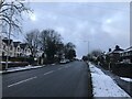
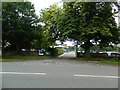
A521 Road in Blythe Bridge
Looking in the direction of Stoke from the western fringes of the village.
Image: © Jonathan Clitheroe
Taken: 23 Jan 2021
0.02 miles
2
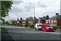
Uttoxeter Road, Blythe Bridge
The A521 climbs gently out of the Blithe valley towards Meir lined with mid-20th century semi-detached (and the odd detached) houses. This was once a stretch of the A50 - life in these houses must be a great deal pleasanter since the by-pass was built.
Image: © Stephen McKay
Taken: 13 May 2021
0.05 miles
3
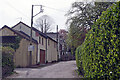
Adamthwaite Drive, Blythe Bridge
Adamthwaite Drive is a private residential road leading off Uttoxeter Road at the western end of Blythe Bridge. The surface is somewhat rough. The house immediately ahead is for sale and the building facing the road hides a more conventional property to the rear.
Image: © Stephen McKay
Taken: 13 May 2021
0.09 miles
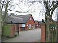
5
Portland School and Specialist College, Blythe Bridge
Image: © John Lord
Taken: 6 Sep 2017
0.16 miles