IMAGES TAKEN NEAR TO
Holly Meadow, STOKE-ON-TRENT, ST10 4RY
Introduction
This page details the photographs taken nearby to Holly Meadow, ST10 4RY by members of the Geograph project.
The Geograph project started in 2005 with the aim of publishing, organising and preserving representative images for every square kilometre of Great Britain, Ireland and the Isle of Man.

There are currently over 7.5m images from over14,400 individuals and you can help contribute to the project by visiting https://www.geograph.org.uk
Image Map
Images are licensed for reuse under creativecommons.org/licenses/by-sa/2.0
Notes
- Clicking on the map will re-center to the selected point.
- The higher the marker number, the further away the image location is from the centre of the postcode.
Image Listing (8 Images Found)
Images are licensed for reuse under creativecommons.org/licenses/by-sa/2.0
Image
Details
Distance
1
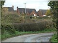
Newish houses in Withington
A small development of detached houses, called Holly Meadow.
Image: © Christine Johnstone
Taken: 2 Nov 2020
0.02 miles
2
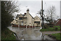
Farmers Arms at Withington
The half-timbered construction is genuine!
Image: © Alan Murray-Rust
Taken: 4 Mar 2007
0.07 miles
3
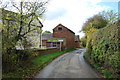
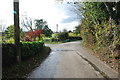
Cuckoo Lane Farm up for Sale
More red brick farm buildings.
Image: © Mick Malpass
Taken: 30 Oct 2011
0.07 miles
4
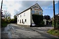
The Farmers Arms at Withington
Fireworks on Friday the 4th November at 7pm with hog roast. There is a post box on the pub wall, watch the cars when posting letters.
Image: © Mick Malpass
Taken: 30 Oct 2011
0.07 miles
5
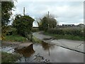
Flooding on a lane south-west of Withington
By coincidence, near a farm called Duck Paddle Farm.
Image: © Christine Johnstone
Taken: 2 Nov 2020
0.10 miles
6
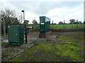
Severn Trent Water infrastructure
On Farm Lane, just south-west of Withington.
Image: © Christine Johnstone
Taken: 2 Nov 2020
0.12 miles
8
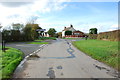
Crossroads looking towards Dods Leigh from Withington
The road to the right is Bents Lane to Church Leigh, the one on the left is Hothill Lane to the Uttoxeter Road.
Image: © Mick Malpass
Taken: 30 Oct 2011
0.25 miles