IMAGES TAKEN NEAR TO
Counslow, STOKE-ON-TRENT, ST10 4QY
Introduction
This page details the photographs taken nearby to Counslow, ST10 4QY by members of the Geograph project.
The Geograph project started in 2005 with the aim of publishing, organising and preserving representative images for every square kilometre of Great Britain, Ireland and the Isle of Man.

There are currently over 7.5m images from over14,400 individuals and you can help contribute to the project by visiting https://www.geograph.org.uk
Image Map (5 Images)


Leaflet Map data © OpenStreetMap
Images are licensed for reuse under creativecommons.org/licenses/by-sa/2.0
Notes
- Clicking on the map will re-center to the selected point.
- The higher the marker number, the further away the image location is from the centre of the postcode.
Image Listing (5 Images Found)
Images are licensed for reuse under creativecommons.org/licenses/by-sa/2.0
Image
Details
Distance
1
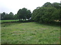
Grazing and woodland
North of Ashbourne Road (B5032).
Image: © JThomas
Taken: 20 Jun 2015
0.05 miles
3
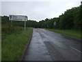
Ashboune 11 miles
Heading east on Ashbourne Road (B5032).
Image: © JThomas
Taken: 20 Jun 2015
0.11 miles
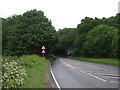
4
B5032 from east towards Cheadle
After skirting the north side of Croxden Quarry, hidden from view to the left, and Counslow Plantation to the right, the road emerges from the trees with this view across towards Cheadle.
Image: © Chris Morgan
Taken: 21 Mar 2012
0.12 miles
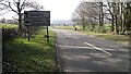
5
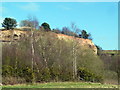
Croxden Quarry
This is one of the largest sand/gravel quarries in Europe and has been in operation since the 1930s. Parts of the quarry, as here, are being restored to woodland, lakes and grassland. See Image for the bigger picture.
Image: © Graham Hogg
Taken: 21 Mar 2012
0.16 miles