IMAGES TAKEN NEAR TO
Lower Nobut, STOKE-ON-TRENT, ST10 4QQ
Introduction
This page details the photographs taken nearby to Lower Nobut, ST10 4QQ by members of the Geograph project.
The Geograph project started in 2005 with the aim of publishing, organising and preserving representative images for every square kilometre of Great Britain, Ireland and the Isle of Man.

There are currently over 7.5m images from over14,400 individuals and you can help contribute to the project by visiting https://www.geograph.org.uk
Image Map
Images are licensed for reuse under creativecommons.org/licenses/by-sa/2.0
Notes
- Clicking on the map will re-center to the selected point.
- The higher the marker number, the further away the image location is from the centre of the postcode.
Image Listing (7 Images Found)
Images are licensed for reuse under creativecommons.org/licenses/by-sa/2.0
Image
Details
Distance
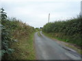
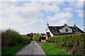
3
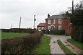
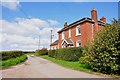
Lower Nobut
Nobbut 3 or 4 houses here!
Image: © Alan Murray-Rust
Taken: 4 Mar 2007
0.12 miles
7
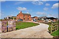
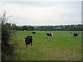
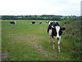
Dagdale Farm at Dagdale
There is some renovation work in progress here, but at least there is still a herd of cows being milked, the tanker is just picking up the milk.
Image: © Mick Malpass
Taken: 14 Apr 2012
0.24 miles