IMAGES TAKEN NEAR TO
Lower Leigh, Leigh, STOKE-ON-TRENT, ST10 4PY
Introduction
This page details the photographs taken nearby to ST10 4PY by members of the Geograph project.
The Geograph project started in 2005 with the aim of publishing, organising and preserving representative images for every square kilometre of Great Britain, Ireland and the Isle of Man.

There are currently over 7.5m images from over14,400 individuals and you can help contribute to the project by visiting https://www.geograph.org.uk
Image Map (Loading...)


Getting Data...Please wait
Leaflet Map data © OpenStreetMap
Images are licensed for reuse under creativecommons.org/licenses/by-sa/2.0
Notes
- Clicking on the map will re-center to the selected point.
- The higher the marker number, the further away the image location is from the centre of the postcode.
Image Listing (24 Images Found)
Images are licensed for reuse under creativecommons.org/licenses/by-sa/2.0
Image
Details
Distance
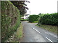
2
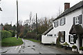
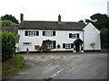
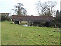
The lane to Upper Leigh
The building on the right appears to have been an alehouse. It carries a stone with the following inscription:
"Walk in my friend and Drink with me
Heres ALE as good as e'er you see
Refresh yourself it is no CRIME
Stay not too long to Spend your time
Francis Sherratt 1751"
Update (via an external correspondent) - until the 1960s this was the Railway Tavern serving Bass products. (Clearly not the original name as there was no railway in 1751!)
Image: © Alan Murray-Rust
Taken: 4 Mar 2007
0.02 miles
3
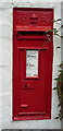
Victorian postbox, Lower Leigh
Postbox No. ST10 123.
See Image] for context.
Image: © JThomas
Taken: 27 Aug 2016
0.02 miles
4
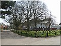
House in Lower Leigh
Showing position of Postbox No. ST10 123.
See Image] for postbox.
Image: © JThomas
Taken: 27 Aug 2016
0.03 miles
5
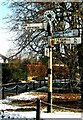
Direction Sign ? Signpost on the green at Lower Leigh
Located on the north corner of the green at Lower Leigh in Leigh parish. 4 arms and annulus finial. See also https://www.geograph.org.uk/photo/1798424.
Milestone Society National ID: ST_SK0136
Image: © J Creber
Taken: Unknown
0.03 miles
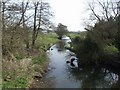
7
River Blithe bridge near Lower Leigh
Concrete bridge built the original stone foundations of an earlier structure.
Image: © John M
Taken: 10 Apr 2010
0.11 miles
8
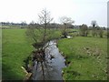
River Blithe upstream near Lower Leigh
Looking towards the Derby to Stoke railway.
Image: © John M
Taken: 10 Apr 2010
0.13 miles