IMAGES TAKEN NEAR TO
Hollington Road, STOKE-ON-TRENT, ST10 4JX
Introduction
This page details the photographs taken nearby to Hollington Road, ST10 4JX by members of the Geograph project.
The Geograph project started in 2005 with the aim of publishing, organising and preserving representative images for every square kilometre of Great Britain, Ireland and the Isle of Man.

There are currently over 7.5m images from over14,400 individuals and you can help contribute to the project by visiting https://www.geograph.org.uk
Image Map
Images are licensed for reuse under creativecommons.org/licenses/by-sa/2.0
Notes
- Clicking on the map will re-center to the selected point.
- The higher the marker number, the further away the image location is from the centre of the postcode.
Image Listing (30 Images Found)
Images are licensed for reuse under creativecommons.org/licenses/by-sa/2.0
Image
Details
Distance
2
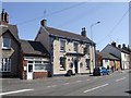
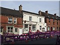
Uttoxeter Road, Upper Tean
Terrace housing in various short sections.
Image: © David Weston
Taken: 29 Jul 2014
0.14 miles
3
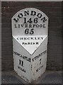
Old Milepost by the A522, High Street, Upper Tean
Cast iron post by the A522 (was A50), in parish of Checkley (Staffordshire Moorlands District), Upper Tean, in tarmac in front of brick wall between windows of house, on South side of road. Thornewill iron casting, erected by the Uttoxeter & Blythe Marsh turnpike trust in the 19th century.
Inscription reads:-
: NEWCASTLE / 11 / MILES : : LONDON / 146 / LIVERPOOL / 65 / CHECKLEY / PARISH : : UTTOXETER / 7 / MILES :
Maker:-
: THORNEWILL / BURTON :
Grade II listed.
List Entry Number: 1280925 https://historicengland.org.uk/listing/the-list/list-entry/1280925
Milestone Society National ID: ST_NCUT11
Image: © Mike Faherty
Taken: 21 Apr 2008
0.15 miles
4
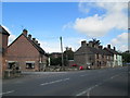
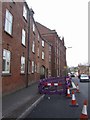
Uttoxeter Road, Upper Tean
The terrace housing along the road is in several sections of varying appearance.
Image: © David Weston
Taken: 29 Jul 2014
0.15 miles
5
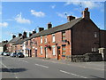
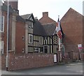
Tean Post Office
19th century Grade 2 listed building in the Conservation Area.
Image: © John M
Taken: 10 Apr 2010
0.15 miles
6
Tean Hall Mills - Old Hall House
The Phillips brothers bought the house and surrounding land in 1747. A tape weaving mill was built bringing together the outworkers from the cottage industry. Further buildings were erected in the 1770s with a larger mill in 1823 housing steam powered Jacquard looms. The Phillips business survived until the 1970s and the mill closed in the 1980s. The buildings have been converted with a mix of private apartments and social housing.
Image: © John M
Taken: 10 Apr 2010
0.16 miles
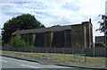
7
Tean Hall Mills - Road frontage
John and Nathaniel Phillips bought the Old Hall House and surrounding land in 1747. A linen tape weaving mill was built bringing together the outworkers from the cottage industry. Further buildings were erected in the 1770s with the impressive Cross Mill built in 1823 to house steam powered Jacquard looms.
The road frontage has the original Hall together with the Loom Mill, Entrance and Finishing Mill.
The Phillips business survived until the 1970s and the mill closed in the 1980s. The buildings have been converted with a mix of private apartments and social housing.
Image: © John M
Taken: 10 Apr 2010
0.16 miles
8
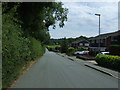
Hollington Road
Old Roman Road heading east.
Image: © JThomas
Taken: 12 Jul 2014
0.16 miles
9
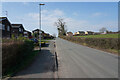
Hollington Road
On the edge of Upper Tean looking along what was a Roman Road.
Image: © Malcolm Neal
Taken: 8 Mar 2022
0.16 miles
10
Catholic Church of St Thomas of Canterbury
Image: © JThomas
Taken: 12 Jul 2014
0.17 miles