IMAGES TAKEN NEAR TO
Riverside Road, STOKE-ON-TRENT, ST10 4JW
Introduction
This page details the photographs taken nearby to Riverside Road, ST10 4JW by members of the Geograph project.
The Geograph project started in 2005 with the aim of publishing, organising and preserving representative images for every square kilometre of Great Britain, Ireland and the Isle of Man.

There are currently over 7.5m images from over14,400 individuals and you can help contribute to the project by visiting https://www.geograph.org.uk
Image Map
Images are licensed for reuse under creativecommons.org/licenses/by-sa/2.0
Notes
- Clicking on the map will re-center to the selected point.
- The higher the marker number, the further away the image location is from the centre of the postcode.
Image Listing (8 Images Found)
Images are licensed for reuse under creativecommons.org/licenses/by-sa/2.0
Image
Details
Distance
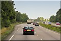
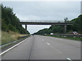
2
A50 near Highfields Farm
Armco barriers protect the long embankment toward Newton.
Image: © Peter Whatley
Taken: 24 Mar 2011
0.19 miles
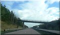
4
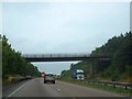
Bridge over A50 to Blythe House
This bridge carries a footpath as well as the access road to Blythe House Image
Image: © David Smith
Taken: 23 Jul 2013
0.21 miles
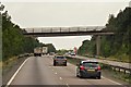
7
A50 - Blythe House accommodation bridge
Image: © Peter Whatley
Taken: 24 Mar 2011
0.22 miles