IMAGES TAKEN NEAR TO
Fir Bob, STOKE-ON-TRENT, ST10 4HT
Introduction
This page details the photographs taken nearby to Fir Bob, ST10 4HT by members of the Geograph project.
The Geograph project started in 2005 with the aim of publishing, organising and preserving representative images for every square kilometre of Great Britain, Ireland and the Isle of Man.

There are currently over 7.5m images from over14,400 individuals and you can help contribute to the project by visiting https://www.geograph.org.uk
Image Map (Loading...)


Getting Data...Please wait
Leaflet Map data © OpenStreetMap
Images are licensed for reuse under creativecommons.org/licenses/by-sa/2.0
Notes
- Clicking on the map will re-center to the selected point.
- The higher the marker number, the further away the image location is from the centre of the postcode.
Image Listing (11 Images Found)
Images are licensed for reuse under creativecommons.org/licenses/by-sa/2.0
Image
Details
Distance
1
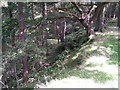
Old quarry, Hollington
Disused, now wooded, stone quarries north of the road through Hollington.
Image: © Dave Dunford
Taken: 1 Sep 2006
0.09 miles
2
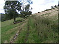
Quarrymen's track, Lodgedale
A well-made track (now a little-used footpath - the worn strip was made by sheep, not people) along the eastern slope of Lodgedale.
Image: © Dave Dunford
Taken: 1 Sep 2006
0.10 miles
3
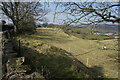
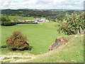
Looking towards Lodge Dale Farm
Looking down a steep valley towards the farm buildings.
Image: © Malcolm Neal
Taken: 8 Mar 2022
0.14 miles
4
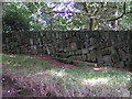
Dry-stone walling, Staffordshire style
This tendency to lay courses of stones at a shallow diagonal seems to be a local tradition, as I saw several walls in the area with a similar style. Earlier in my walk I said good morning to someone dry-stone-walling as I passed by, but he appeared to be laying his courses conventionally (i.e. horizontally).
Image: © Dave Dunford
Taken: 1 Sep 2006
0.15 miles
5
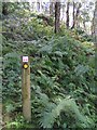
In Broadmoor Wood
Well-named: I felt ready for Broadmoor after blundering about in bouldery bracken trying to find the footpath to Lodgedale. I was reassured to find this sign indicating that (despite appearances) I was still in the right place. The path is fairly well signposted, but obviously not well used. I got utterly lost in the same wood a bit later, near the Raddle Inn in Hollington.
Image: © Dave Dunford
Taken: 1 Sep 2006
0.15 miles
6
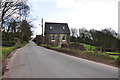
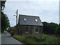
Buildings on the road through Hollington
Image: © Mick Malpass
Taken: 14 Apr 2012
0.19 miles
7
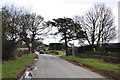
Now Entering Hollington from Upper Tean
Image: © Mick Malpass
Taken: 14 Apr 2012
0.19 miles
9
Lodgedale
Looking towards Lodgedale Farm from a rock outcrop close to the Hollington road.
Image: © Dave Dunford
Taken: 1 Sep 2006
0.22 miles
10
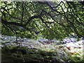
Underneath the spreading chestnut tree
One of a grove of sweet chestnut trees in Broadmoor Wood; this one is right on the hairpin bend between Great Gate and Hollington.
Image: © Dave Dunford
Taken: 1 Sep 2006
0.23 miles