IMAGES TAKEN NEAR TO
Hollington, STOKE-ON-TRENT, ST10 4HH
Introduction
This page details the photographs taken nearby to ST10 4HH by members of the Geograph project.
The Geograph project started in 2005 with the aim of publishing, organising and preserving representative images for every square kilometre of Great Britain, Ireland and the Isle of Man.

There are currently over 7.5m images from over14,400 individuals and you can help contribute to the project by visiting https://www.geograph.org.uk
Image Map (Loading...)


Getting Data...Please wait
Leaflet Map data © OpenStreetMap
Images are licensed for reuse under creativecommons.org/licenses/by-sa/2.0
Notes
- Clicking on the map will re-center to the selected point.
- The higher the marker number, the further away the image location is from the centre of the postcode.
Image Listing (18 Images Found)
Images are licensed for reuse under creativecommons.org/licenses/by-sa/2.0
Image
Details
Distance

6
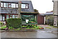
Plants and Free Range Eggs for sale in Rectory Road
Image: © Mick Malpass
Taken: 9 Apr 2012
0.08 miles
8
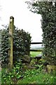
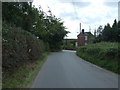
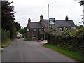
Fingerpost and Stile, Rectory Road at Hollington
This footpath crosses farmland towards Beamhurst.
Image: © Mick Malpass
Taken: 9 Apr 2012
0.10 miles
10
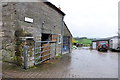
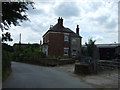
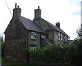
Farmyard for New Close Farm in Rectory Road
Most of the buildings in this village are made out of stone, similar to this farm building.
Image: © Mick Malpass
Taken: 9 Apr 2012
0.13 miles