IMAGES TAKEN NEAR TO
Bradley In The Moors, STOKE-ON-TRENT, ST10 4DG
Introduction
This page details the photographs taken nearby to Bradley In The Moors, ST10 4DG by members of the Geograph project.
The Geograph project started in 2005 with the aim of publishing, organising and preserving representative images for every square kilometre of Great Britain, Ireland and the Isle of Man.

There are currently over 7.5m images from over14,400 individuals and you can help contribute to the project by visiting https://www.geograph.org.uk
Image Map
Images are licensed for reuse under creativecommons.org/licenses/by-sa/2.0
Notes
- Clicking on the map will re-center to the selected point.
- The higher the marker number, the further away the image location is from the centre of the postcode.
Image Listing (5 Images Found)
Images are licensed for reuse under creativecommons.org/licenses/by-sa/2.0
Image
Details
Distance
1
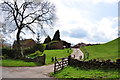
New Farm, between Newton and Bradley in the Moors
Image: © Mick Malpass
Taken: 14 Apr 2012
0.03 miles
2
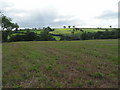
New Farm
From the footpath between Bradley in the Moors and Alton Common.
Image: © Dave Dunford
Taken: 1 Sep 2006
0.06 miles
3
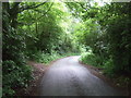
Bend in the lane towards Bradley in the Moors
Image: © JThomas
Taken: 20 Jun 2015
0.12 miles
4
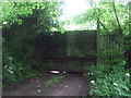
Private entrance, Peakstone Rock
Off the lane towards Bradley in the Moors.
Image: © JThomas
Taken: 20 Jun 2015
0.13 miles
5
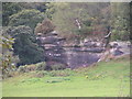
Peakstone Rock
Taken with zoom from footpath between Bradley in the Moors and Alton Common.
Image: © Dave Dunford
Taken: 1 Sep 2006
0.14 miles