IMAGES TAKEN NEAR TO
The Orchard, STOKE-ON-TRENT, ST10 4DA
Introduction
This page details the photographs taken nearby to The Orchard, ST10 4DA by members of the Geograph project.
The Geograph project started in 2005 with the aim of publishing, organising and preserving representative images for every square kilometre of Great Britain, Ireland and the Isle of Man.

There are currently over 7.5m images from over14,400 individuals and you can help contribute to the project by visiting https://www.geograph.org.uk
Image Map (Loading...)


Getting Data...Please wait
Leaflet Map data © OpenStreetMap
Images are licensed for reuse under creativecommons.org/licenses/by-sa/2.0
Notes
- Clicking on the map will re-center to the selected point.
- The higher the marker number, the further away the image location is from the centre of the postcode.
Image Listing (25 Images Found)
Images are licensed for reuse under creativecommons.org/licenses/by-sa/2.0
Image
Details
Distance
1
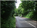
Lime Kiln Lane
Heading north west into Alton.
Image: © JThomas
Taken: 20 Jun 2015
0.09 miles
2
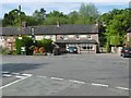
Alton, Royal Oak
Public house on Cedarhill.
Image: © Mike Faherty
Taken: 13 May 2018
0.10 miles
3
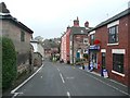
The Post Office
No passing trade at present, as the road has been closed for highway repairs.
Image: © Humphrey Bolton
Taken: 11 Nov 2009
0.10 miles
4
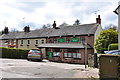
The Royal Oak at Alton
This public house looks rather nondescript from the outside, but when you look at their website, it deserves a visit. http://www.royaloak-alton.co.uk/index.htm
Image: © Mick Malpass
Taken: 14 Apr 2012
0.11 miles
5
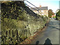
Knight Lane, Alton
View of stone cottages, Knight Lane, Alton
Image: © Hazel Mills
Taken: 16 Jun 2011
0.11 miles
6
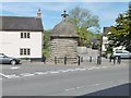
Alton, lock-up
On Dimble Lane, dating from 1819; listed by Historic England (Grade II): http://www.imagesofengland.org.uk/Details/Default.aspx?id=275009&mode=adv
Image: © Mike Faherty
Taken: 13 May 2018
0.12 miles
8
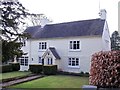
Red Lion Cottage
This was once a yeoman farmhouse and, despite remodelling over the centuries, is still original enough to be grade 2 listed. The date stone above the door reads "A.K. 1657". There used to be a Red Lion pub somewhere in the village but I have found no evidence online to support this being it. It was also known, at one time, as Yewtree Cottage.
Image: © Ian Calderwood
Taken: 6 Apr 2013
0.13 miles
9
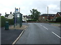
Bus stop and shelter on Uttoxeter Road
Looking south.
Image: © JThomas
Taken: 20 Jun 2015
0.15 miles
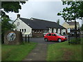
10
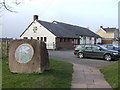
Alton Village Hall
The village hall has a car park which is a handy base for exploring Alton and the Churnet Valley.
Image: © Ian Calderwood
Taken: 21 Mar 2009
0.16 miles