IMAGES TAKEN NEAR TO
Rakesdale, STOKE-ON-TRENT, ST10 4BT
Introduction
This page details the photographs taken nearby to Rakesdale, ST10 4BT by members of the Geograph project.
The Geograph project started in 2005 with the aim of publishing, organising and preserving representative images for every square kilometre of Great Britain, Ireland and the Isle of Man.

There are currently over 7.5m images from over14,400 individuals and you can help contribute to the project by visiting https://www.geograph.org.uk
Image Map (Loading...)


Getting Data...Please wait
Leaflet Map data © OpenStreetMap
Images are licensed for reuse under creativecommons.org/licenses/by-sa/2.0
Notes
- Clicking on the map will re-center to the selected point.
- The higher the marker number, the further away the image location is from the centre of the postcode.
Image Listing (14 Images Found)
Images are licensed for reuse under creativecommons.org/licenses/by-sa/2.0
Image
Details
Distance
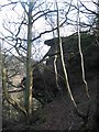
1
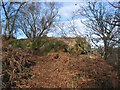
Toothill Rock
Toothill Rock - a popular viewpoint above the River Churnet, Alton
Image: © Dennis Thorley
Taken: 10 Feb 2006
0.13 miles
2
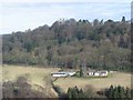
View from Toothill Rock
View across the Churnet Valley from Toothill Rock towards the Flag Tower (just inside Image) part of the Alton Towers Leisure Park complex.
Image: © Dennis Thorley
Taken: 10 Feb 2006
0.13 miles
3
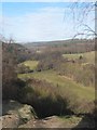
View up the Churnet Valley from Toothill Rock
View north west up the Churnet Valley from Toothill Rock.
Image: © Dennis Thorley
Taken: 10 Feb 2006
0.13 miles
5
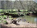
Broken weir on the Churnet
This weir used to supply a head of water to the mill pond that fed Alton Mill.
Image: © Ian Calderwood
Taken: 10 Apr 2011
0.15 miles
6
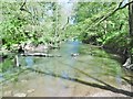
Alton, River Churnet
Looking upstream from the disused weir.
Image: © Mike Faherty
Taken: 14 May 2018
0.15 miles
7

Alton, disused weir
What appears at first glance to be a stone wall partially crossing River Churnet seems to be a disused weir, according to OS. Looking downstream.
Image: © Mike Faherty
Taken: 14 May 2018
0.15 miles
8
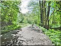
Alton, railway trackbed
Formerly the North Staffordshire Railway line from Macclesfield to Derby; closed in 1965, now a traffic-free cycle route.
Image: © Mike Faherty
Taken: 14 May 2018
0.17 miles
9
Toothill Rock
A popular viewpoint above the River Churnet near Alton
Image: © Dennis Thorley
Taken: 10 Feb 2006
0.18 miles
10
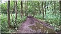
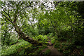
Churnet Valley trail
On track of old railway
Image: © Chris Morgan
Taken: 17 Aug 2015
0.18 miles