IMAGES TAKEN NEAR TO
Saltersford Lane, STOKE-ON-TRENT, ST10 4AU
Introduction
This page details the photographs taken nearby to Saltersford Lane, ST10 4AU by members of the Geograph project.
The Geograph project started in 2005 with the aim of publishing, organising and preserving representative images for every square kilometre of Great Britain, Ireland and the Isle of Man.

There are currently over 7.5m images from over14,400 individuals and you can help contribute to the project by visiting https://www.geograph.org.uk
Image Map (Loading...)


Getting Data...Please wait
Leaflet Map data © OpenStreetMap
Images are licensed for reuse under creativecommons.org/licenses/by-sa/2.0
Notes
- Clicking on the map will re-center to the selected point.
- The higher the marker number, the further away the image location is from the centre of the postcode.
Image Listing (13 Images Found)
Images are licensed for reuse under creativecommons.org/licenses/by-sa/2.0
Image
Details
Distance
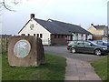
1
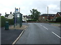
Bus stop and shelter on Uttoxeter Road
Looking south.
Image: © JThomas
Taken: 20 Jun 2015
0.08 miles
2
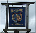
Sign for the Blacksmiths Arms, Gallows Green
Image: © JThomas
Taken: 20 Jun 2015
0.09 miles
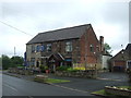
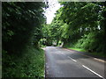
5
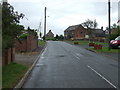
B5032, Gallows Green
Heading east approaching the Blacksmiths Arms public house.
Image: © JThomas
Taken: 20 Jun 2015
0.13 miles
7
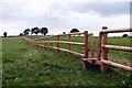
New paddock
Horses to be on the other side
Image: © Chris Morgan
Taken: 17 Aug 2015
0.16 miles
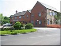
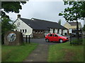
8
Alton Village Hall
The village hall has a car park which is a handy base for exploring Alton and the Churnet Valley.
Image: © Ian Calderwood
Taken: 21 Mar 2009
0.16 miles
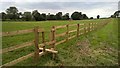
9
New fencing with stile
In fields above Alton
Image: © Graham Hogg
Taken: 17 Aug 2015
0.17 miles
10
Lime Kiln Lane
Heading north west into Alton.
Image: © JThomas
Taken: 20 Jun 2015
0.18 miles