IMAGES TAKEN NEAR TO
Malthouse Road, STOKE-ON-TRENT, ST10 4AG
Introduction
This page details the photographs taken nearby to Malthouse Road, ST10 4AG by members of the Geograph project.
The Geograph project started in 2005 with the aim of publishing, organising and preserving representative images for every square kilometre of Great Britain, Ireland and the Isle of Man.

There are currently over 7.5m images from over14,400 individuals and you can help contribute to the project by visiting https://www.geograph.org.uk
Image Map
Images are licensed for reuse under creativecommons.org/licenses/by-sa/2.0
Notes
- Clicking on the map will re-center to the selected point.
- The higher the marker number, the further away the image location is from the centre of the postcode.
Image Listing (34 Images Found)
Images are licensed for reuse under creativecommons.org/licenses/by-sa/2.0
Image
Details
Distance
1
Alton Tiles
A tile shop seems surprising in a such a small village. It has preserved an elegant shop front of red sandstone, on which is carved the name 'Byatt'.
Image: © Humphrey Bolton
Taken: 11 Nov 2009
0.03 miles
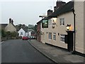
2
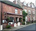
High Street and the Black Bull, Alton
The Black Bull seemed to be the only place in Alton serving lunches on a November weekday, and we enjoyed it enough to come back the next day.
Image: © Humphrey Bolton
Taken: 11 Nov 2009
0.03 miles
3
Alton Methodist Church
On New Road, dating from 1826: http://www.staffmoorlandsmethodists.org.uk/churches/alton/
Image: © Mike Faherty
Taken: 13 May 2018
0.05 miles
4
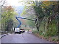
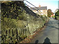
Tree cutting, New Road, Alton
The road was closed for carriageway repairs, but it was evidently an ideal opportunity to cut back overhanging trees. On the way down we used a steep cobbled footpath to the left, which went past the Talbot Inn. This was evidently the old road. This new road is probably over a century old now.
Image: © Humphrey Bolton
Taken: 11 Nov 2009
0.06 miles
5
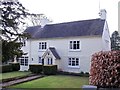
Red Lion Cottage
This was once a yeoman farmhouse and, despite remodelling over the centuries, is still original enough to be grade 2 listed. The date stone above the door reads "A.K. 1657". There used to be a Red Lion pub somewhere in the village but I have found no evidence online to support this being it. It was also known, at one time, as Yewtree Cottage.
Image: © Ian Calderwood
Taken: 6 Apr 2013
0.06 miles
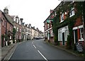
6
Knight Lane, Alton
View of stone cottages, Knight Lane, Alton
Image: © Hazel Mills
Taken: 16 Jun 2011
0.07 miles
7
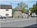
Alton, lock-up
On Dimble Lane, dating from 1819; listed by Historic England (Grade II): http://www.imagesofengland.org.uk/Details/Default.aspx?id=275009&mode=adv
Image: © Mike Faherty
Taken: 13 May 2018
0.07 miles
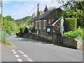
8
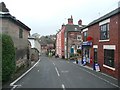
The Post Office
No passing trade at present, as the road has been closed for highway repairs.
Image: © Humphrey Bolton
Taken: 11 Nov 2009
0.08 miles
9
The White Hart, High Street, Alton
Welcoming lights, although it was not yet four o'clock and the pub did not as if it was open.
Image: © Humphrey Bolton
Taken: 11 Nov 2009
0.09 miles
10
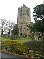
St Peter's Church, Alton
This church has a Norman north arcade (rebuilt in 1830, as was most of the church). This view shows the 14C tower.
Image: © Humphrey Bolton
Taken: 11 Nov 2009
0.09 miles