IMAGES TAKEN NEAR TO
Whitefields Lane, STOKE-ON-TRENT, ST10 3JF
Introduction
This page details the photographs taken nearby to Whitefields Lane, ST10 3JF by members of the Geograph project.
The Geograph project started in 2005 with the aim of publishing, organising and preserving representative images for every square kilometre of Great Britain, Ireland and the Isle of Man.

There are currently over 7.5m images from over14,400 individuals and you can help contribute to the project by visiting https://www.geograph.org.uk
Image Map
Images are licensed for reuse under creativecommons.org/licenses/by-sa/2.0
Notes
- Clicking on the map will re-center to the selected point.
- The higher the marker number, the further away the image location is from the centre of the postcode.
Image Listing (18 Images Found)
Images are licensed for reuse under creativecommons.org/licenses/by-sa/2.0
Image
Details
Distance
1
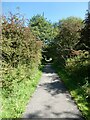
Cycle route leading to the Manifold Way, Waterhouses
Part of the path linking the car park with the start of the Manifold Way
Image: © David Smith
Taken: 5 Sep 2023
0.16 miles
2
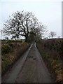
Minor road to Waterfall
This very narrow lane leads to Waterfall from Waterhouses. For some reason, it is the preferred route for my satnav, though there is a much wider and shorter road just to the west.
Image: © Gordon Brown
Taken: 20 Feb 2011
0.16 miles
3
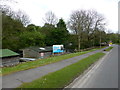
Election poster
There is a general election on, and I would have expected a great many more posters. But while crossing the southern Pennines, I saw posters only for one candidate in one constituency. That one constituency was scattered with a lot of posters for that candidate.
See Image for a closeup of the poster
Image: © Bob Harvey
Taken: 21 May 2017
0.16 miles
4

Election poster
The election poster seen in Image
Image: © Bob Harvey
Taken: 21 May 2017
0.16 miles
5
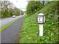
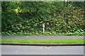
Waterhouses, milepost
A distinctive "bobbin" style milepost on A523, showing distances to Leek (8), Ashbourne (7) and London (146). Dated 1834 and listed by English Heritage: http://www.imagesofengland.org.uk/Details/default.aspx?pid=2&id=275195
Image: © Mike Faherty
Taken: 10 May 2012
0.17 miles
6

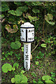
Old Milepost by the A523, Waterhouses
Cast iron post by the A523, in parish of WATERHOUSES (STAFFORDSHIRE MOORLANDS District), Waterhouses village, At end of footpath by tunnel under former railway bridge, on South side of road. Ashbourne iron bobbin, erected by the Ashbourne to Leek & Congleton turnpike trust in the 19th century.
Inscription reads:-
: LEEK / 8 / MILES. : : LONDON 146 MILES. : : ASHBN.. / 7 / MILES :
Maker:-
: JAMES BASSETT ASHBOURNE 1834. :
Grade II listed.
List Entry Number: 1037832 https://historicengland.org.uk/listing/the-list/list-entry/1037832
Milestone Society National ID: ST_LKAB08.
Image: © J Higgins
Taken: 1 Jan 2000
0.17 miles
7
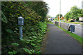
Milepost on the A523 in Waterhouses
A Grade II listed structure https://historicengland.org.uk/listing/the-list/list-entry/1037832 .
Image: © David Lally
Taken: 24 Aug 2011
0.17 miles
8
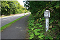
Milepost on the A523 in Waterhouses
A Grade II listed structure https://historicengland.org.uk/listing/the-list/list-entry/1037832 .
Image: © David Lally
Taken: 24 Aug 2011
0.17 miles
9
Milepost on the A523 in Waterhouses
A Grade II listed structure https://historicengland.org.uk/listing/the-list/list-entry/1037832 .
Image: © David Lally
Taken: 24 Aug 2011
0.17 miles
10
Milepost on the A523 in Waterhouses
A Grade II listed structure https://historicengland.org.uk/listing/the-list/list-entry/1037832 .
Image: © David Lally
Taken: 24 Aug 2011
0.17 miles