IMAGES TAKEN NEAR TO
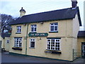
The Boundary, STOKE-ON-TRENT, ST10 2NU
Introduction
This page details the photographs taken nearby to The Boundary, ST10 2NU by members of the Geograph project.
The Geograph project started in 2005 with the aim of publishing, organising and preserving representative images for every square kilometre of Great Britain, Ireland and the Isle of Man.

There are currently over 7.5m images from over14,400 individuals and you can help contribute to the project by visiting https://www.geograph.org.uk
Image Map
Images are licensed for reuse under creativecommons.org/licenses/by-sa/2.0
Notes
- Clicking on the map will re-center to the selected point.
- The higher the marker number, the further away the image location is from the centre of the postcode.
Image Listing (8 Images Found)
Images are licensed for reuse under creativecommons.org/licenses/by-sa/2.0
Image
Details
Distance
1
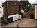
Little Road at Boundary village
They weren't kidding when they named this street!
Image: © Jerry Evans
Taken: 28 Jun 2007
0.03 miles

6
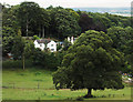
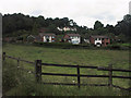
Boundary
The settlement of Boundary is on quite a winding ridge. This view is from Commonside looking across the valley to houses of Delphouse Road.
Image: © Jerry Evans
Taken: 28 Jun 2007
0.13 miles

