IMAGES TAKEN NEAR TO
Bottom Lane, STOKE-ON-TRENT, ST10 2LN
Introduction
This page details the photographs taken nearby to Bottom Lane, ST10 2LN by members of the Geograph project.
The Geograph project started in 2005 with the aim of publishing, organising and preserving representative images for every square kilometre of Great Britain, Ireland and the Isle of Man.

There are currently over 7.5m images from over14,400 individuals and you can help contribute to the project by visiting https://www.geograph.org.uk
Image Map (Loading...)


Getting Data...Please wait
Leaflet Map data © OpenStreetMap
Images are licensed for reuse under creativecommons.org/licenses/by-sa/2.0
Notes
- Clicking on the map will re-center to the selected point.
- The higher the marker number, the further away the image location is from the centre of the postcode.
Image Listing (28 Images Found)
Images are licensed for reuse under creativecommons.org/licenses/by-sa/2.0
Image
Details
Distance
1
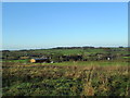
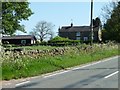
Farm buildings along Bottom Lane
Looking from Blakelow towards Bottom Lane, the B5053 to Ipstones. On the left of the photo is a bridge where the road crosses a railway line (the Cauldon Lowe branch of the Churnet Valley Railway).
Image: © David Weston
Taken: 7 Nov 2013
0.01 miles
2
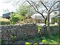
Public footpath through a front garden
On the east side of Bottom Lane, at Little Blakelow.
Image: © Christine Johnstone
Taken: 27 May 2012
0.02 miles
3
Little Blakelow paddock
Hope the horse enjoys a buttercup-rich diet.
Image: © Christine Johnstone
Taken: 27 May 2012
0.02 miles
4
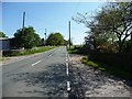
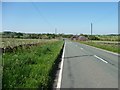
Bottom Lane at Little Blakelow
The B5053 is a former turnpike toll road.
Image: © Christine Johnstone
Taken: 27 May 2012
0.03 miles
5
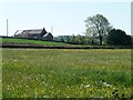
Little Blakelow Farm
On the north side of Bottom Lane [B5053].
Image: © Christine Johnstone
Taken: 27 May 2012
0.06 miles
6
Bottom Lane at Little Blakelow
Looking south-west towards the railway bridge.
Image: © Christine Johnstone
Taken: 27 May 2012
0.07 miles
7
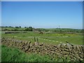
Wild flower meadow, Little Blakelow
South of Bottom Lane [B5053].
Image: © Christine Johnstone
Taken: 27 May 2012
0.09 miles
8

New trees and old buildings, Blakelow
Seen from a train on the Churnet Valley Railway's Cauldon Lowe branch.
Image: © Christine Johnstone
Taken: 27 May 2012
0.11 miles
9
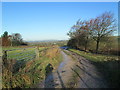
Lane to farmhouse at Blakelow
Looking towards Bottom Lane (the B5053 to Ipstones).
Image: © David Weston
Taken: 7 Nov 2013
0.12 miles
10
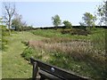
Blakelow Common
Blakelow Common is a small area of open-access land with parking space for a few cars. There are picnic tables, benches and a view point with a plaque describing what may be seen.
Image: © Ian Calderwood
Taken: 5 May 2007
0.12 miles