IMAGES TAKEN NEAR TO
Whirley Low, STOKE-ON-TRENT, ST10 2HR
Introduction
This page details the photographs taken nearby to Whirley Low, ST10 2HR by members of the Geograph project.
The Geograph project started in 2005 with the aim of publishing, organising and preserving representative images for every square kilometre of Great Britain, Ireland and the Isle of Man.

There are currently over 7.5m images from over14,400 individuals and you can help contribute to the project by visiting https://www.geograph.org.uk
Image Map (Loading...)


Getting Data...Please wait
Leaflet Map data © OpenStreetMap
Images are licensed for reuse under creativecommons.org/licenses/by-sa/2.0
Notes
- Clicking on the map will re-center to the selected point.
- The higher the marker number, the further away the image location is from the centre of the postcode.
Image Listing (9 Images Found)
Images are licensed for reuse under creativecommons.org/licenses/by-sa/2.0
Image
Details
Distance
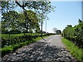
1
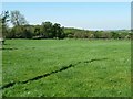
Farmland north-west of the road to Foxt
With the shadow of a roadside telegraph pole.
Image: © Christine Johnstone
Taken: 27 May 2012
0.08 miles
2
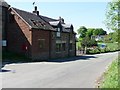
Post-box alongside a renovated cottage
On the road to Foxt.
Image: © Christine Johnstone
Taken: 27 May 2012
0.10 miles
3
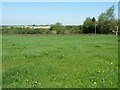
Farmland west of Park Lane
With Ipstones Edge on the horizon.
Image: © Christine Johnstone
Taken: 27 May 2012
0.10 miles
4
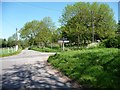
Crossroads at the 276 metre spot height
Shaw-wall Lane meeting Park Lane, at the road from Froghall and Foxt to Winkhill.
Image: © Christine Johnstone
Taken: 27 May 2012
0.11 miles
5
Shaw-wall Lane
Looking south-east wards towards Shaw-wall and Lanehead.
Image: © Christine Johnstone
Taken: 27 May 2012
0.11 miles
6

Cycling up to Winkhill
And no doubt beyond, despite the heat.
Image: © Christine Johnstone
Taken: 27 May 2012
0.14 miles
7
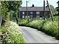
Four terraced houses alongside the road to Winkhill
Between Parkside and Gorstycroft Farms.
Image: © Christine Johnstone
Taken: 27 May 2012
0.19 miles
8
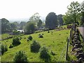
Town Head
A view over the hamlet of Town Head taken from just above Gorstycroft.
Image: © Mike Bardill
Taken: 6 Jun 2007
0.24 miles
9
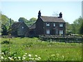
Gorstycroft Farmhouse
Seen from Shaw-wall Lane.
Image: © Christine Johnstone
Taken: 27 May 2012
0.25 miles