IMAGES TAKEN NEAR TO
Ashbourne Road, STOKE-ON-TRENT, ST10 1SJ
Introduction
This page details the photographs taken nearby to Ashbourne Road, ST10 1SJ by members of the Geograph project.
The Geograph project started in 2005 with the aim of publishing, organising and preserving representative images for every square kilometre of Great Britain, Ireland and the Isle of Man.

There are currently over 7.5m images from over14,400 individuals and you can help contribute to the project by visiting https://www.geograph.org.uk
Image Map
Images are licensed for reuse under creativecommons.org/licenses/by-sa/2.0
Notes
- Clicking on the map will re-center to the selected point.
- The higher the marker number, the further away the image location is from the centre of the postcode.
Image Listing (3 Images Found)
Images are licensed for reuse under creativecommons.org/licenses/by-sa/2.0
Image
Details
Distance
1
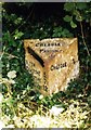
Old Milepost by the B5032, Ashbourne Road, Lightwood Farm
Cast iron post by the B5032, in parish of CHEADLE (STAFFORDSHIRE MOORLANDS District), Lightwood, East of Cheadle, in hedge, on North side of road. Cochrane iron casting, erected by the County Council in the 20th century.
Inscription reads:-
: ALTON 3½ / DENSTONE 5½ / ELLASTONE 7¼ / ASHBOURNE 12 : : CHEADLE / PARISH : : CHEADLE 1 :
Maker:-
: Cochrane & Co, Dudley. :
Staffordshire HER listed.
HER Number: 51265 https://www.heritagegateway.org.uk/Gateway/Results_Single.aspx?uid=MST12485&resourceID=1010
Milestone Society National ID: ST_ABCD12.
Image: © J Higgins
Taken: 1 Jan 2000
0.06 miles
2
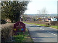
Approaching Cheadle
From the east on the B5052. We failed to discover Cheadle's secret (unless it's the low cost of car parking!)
Image: © Graham Hogg
Taken: 21 Mar 2012
0.15 miles