IMAGES TAKEN NEAR TO
Coppice Lane, STOKE-ON-TRENT, ST10 1RQ
Introduction
This page details the photographs taken nearby to Coppice Lane, ST10 1RQ by members of the Geograph project.
The Geograph project started in 2005 with the aim of publishing, organising and preserving representative images for every square kilometre of Great Britain, Ireland and the Isle of Man.

There are currently over 7.5m images from over14,400 individuals and you can help contribute to the project by visiting https://www.geograph.org.uk
Image Map
Images are licensed for reuse under creativecommons.org/licenses/by-sa/2.0
Notes
- Clicking on the map will re-center to the selected point.
- The higher the marker number, the further away the image location is from the centre of the postcode.
Image Listing (3 Images Found)
Images are licensed for reuse under creativecommons.org/licenses/by-sa/2.0
Image
Details
Distance
1
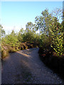
Track leading to a camping field
This track joined the camping field with the reception and runs along the quarry edge.
Image: © Linda Bailey
Taken: 29 Aug 2006
0.13 miles
2

Play Area at Quarry Park
This old quarry is now a camping and caravan park - but at the back of the play area you can see the old sides of the quarry.
Image: © Linda Bailey
Taken: 29 Aug 2006
0.14 miles
3
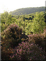
Old Quarry near Freehay
Near the edge of the quarry lip - the birch trees are down in the old quarry base, looking towards the south-east. The central part of the quarry is now a caravan park, and there is a camping area on the quarry top.
Image: © Linda Bailey
Taken: 29 Aug 2006
0.22 miles