IMAGES TAKEN NEAR TO
Rakeway Road, STOKE-ON-TRENT, ST10 1RA
Introduction
This page details the photographs taken nearby to Rakeway Road, ST10 1RA by members of the Geograph project.
The Geograph project started in 2005 with the aim of publishing, organising and preserving representative images for every square kilometre of Great Britain, Ireland and the Isle of Man.

There are currently over 7.5m images from over14,400 individuals and you can help contribute to the project by visiting https://www.geograph.org.uk
Image Map (Loading...)


Getting Data...Please wait
Leaflet Map data © OpenStreetMap
Images are licensed for reuse under creativecommons.org/licenses/by-sa/2.0
Notes
- Clicking on the map will re-center to the selected point.
- The higher the marker number, the further away the image location is from the centre of the postcode.
Image Listing (5 Images Found)
Images are licensed for reuse under creativecommons.org/licenses/by-sa/2.0
Image
Details
Distance
1
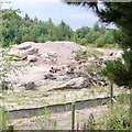
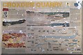
Croxden Quarry
near Freehay. In this area the contractors, Tarmac have got no further than removing the overburden. But within the next ten years this area will be dug out to a depth of 30 metres or more. In the foreground there is a curious metal "wall" with a curved top about a metre high. This may well be to keep some species of small furry animal out of the dangerous site.
Image: © Roger W Haworth
Taken: 15 Aug 2006
0.13 miles
2
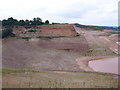
Croxden Quarry
Sand and gravel extraction, operated by Tarmac. The face in the distance appears still to be active; mortar works out of sight. As seen from the viewpoint on Coppice Lane.
Image: © Mike Faherty
Taken: 12 May 2018
0.19 miles
4
The Queens at Freehay
Looks like a nice pub - right beside one of the most massive quarries in Britain.
Image: © Chris Morgan
Taken: 21 Mar 2012
0.20 miles
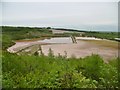
5
Croxden Quarry
Freehay. Until a few years ago Counslow Road ran more or less level from the photographer's position to the top of the far cliff (a point about one third of the picture width from the left hand edge). The current Multimap aerial image http://www.multimap.com/map/photo.cgi?x=402638&y=341787&scale=10000 shows the road intact and the new Counslow Road being constructed in a sweeping curve to the west and north. The new road opened in 2000 at a cost of £2 million. Since then Tarmac, the quarry operators have carved out this great trench.
Image: © Roger W Haworth
Taken: 15 Aug 2006
0.21 miles