IMAGES TAKEN NEAR TO
Hudson Crescent, LEIGH-ON-SEA, SS9 5XU
Introduction
This page details the photographs taken nearby to Hudson Crescent, SS9 5XU by members of the Geograph project.
The Geograph project started in 2005 with the aim of publishing, organising and preserving representative images for every square kilometre of Great Britain, Ireland and the Isle of Man.

There are currently over 7.5m images from over14,400 individuals and you can help contribute to the project by visiting https://www.geograph.org.uk
Image Map
Images are licensed for reuse under creativecommons.org/licenses/by-sa/2.0
Notes
- Clicking on the map will re-center to the selected point.
- The higher the marker number, the further away the image location is from the centre of the postcode.
Image Listing (13 Images Found)
Images are licensed for reuse under creativecommons.org/licenses/by-sa/2.0
Image
Details
Distance
1
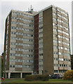
Beaver Tower, Mansell Close, Eastwood
Beaver Tower is one of Southend's thirteen tower blocks and was completed in the mid-1960s.
Image: © David Kemp
Taken: 28 Oct 2016
0.06 miles
2
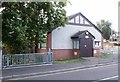
Eastwood Memorial Hall
A Memorial built to those who fell in the Great War.
On the Corner of Lambeth Road and Rayleigh Road, next to the Brook.
Image: © Paul Collins
Taken: 17 Jul 2007
0.15 miles
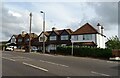
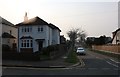
5
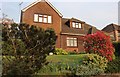
House and garden on Bellhouse Road, Eastwood
Image: © David Howard
Taken: 8 Apr 2019
0.22 miles
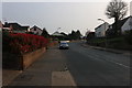
9
Bellhouse Road at the junction of Leighfields Road
Image: © David Howard
Taken: 8 Apr 2019
0.23 miles
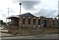
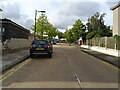
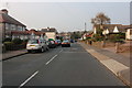
10
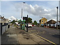
Bus stop and shelter on Rayleigh Road (A1015), Eastwood
Image: © JThomas
Taken: 25 Aug 2022
0.24 miles