IMAGES TAKEN NEAR TO
Aldrin Way, LEIGH-ON-SEA, SS9 5UA
Introduction
This page details the photographs taken nearby to Aldrin Way, SS9 5UA by members of the Geograph project.
The Geograph project started in 2005 with the aim of publishing, organising and preserving representative images for every square kilometre of Great Britain, Ireland and the Isle of Man.

There are currently over 7.5m images from over14,400 individuals and you can help contribute to the project by visiting https://www.geograph.org.uk
Image Map
Images are licensed for reuse under creativecommons.org/licenses/by-sa/2.0
Notes
- Clicking on the map will re-center to the selected point.
- The higher the marker number, the further away the image location is from the centre of the postcode.
Image Listing (9 Images Found)
Images are licensed for reuse under creativecommons.org/licenses/by-sa/2.0
Image
Details
Distance
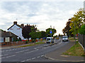
1
Aldrin Way, Southend-On-Sea
Junction with Lovell Rise.
Image: © JThomas
Taken: 25 Aug 2022
0.02 miles
3
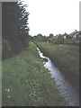
Eastwood Brook
The only significant feature in this square of non-descript housing and industrial estates.
Image: © John Myers
Taken: 28 May 2007
0.18 miles
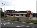
4
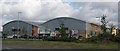
David Lloyd Tennis Centre
The new David Lloyd Centre, Snakes Lane, Eastwood, Leigh-on-Sea.
Image: © Paul Collins
Taken: 17 Jul 2007
0.19 miles
5
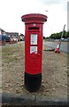
George V postbox on Snakes Lane, Southend-on-Sea
Postbox No. SS2 13.
See Image] for context.
Image: © JThomas
Taken: 25 Aug 2022
0.20 miles
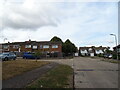
6
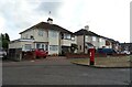
Houses on Snakes Lane, Southend-on-Sea
Showing position of Postbox No. SS2 13.
See Image] for postbox.
Image: © JThomas
Taken: 25 Aug 2022
0.20 miles
7
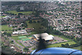
Through the Prop
The building partly hidden behind the propeller is Image
The plane is a Dragon Rapide DH89A. See Image
Image: © terry joyce
Taken: 22 Jun 2008
0.21 miles