IMAGES TAKEN NEAR TO
Fairfield Crescent, LEIGH-ON-SEA, SS9 5SQ
Introduction
This page details the photographs taken nearby to Fairfield Crescent, SS9 5SQ by members of the Geograph project.
The Geograph project started in 2005 with the aim of publishing, organising and preserving representative images for every square kilometre of Great Britain, Ireland and the Isle of Man.

There are currently over 7.5m images from over14,400 individuals and you can help contribute to the project by visiting https://www.geograph.org.uk
Image Map
Images are licensed for reuse under creativecommons.org/licenses/by-sa/2.0
Notes
- Clicking on the map will re-center to the selected point.
- The higher the marker number, the further away the image location is from the centre of the postcode.
Image Listing (8 Images Found)
Images are licensed for reuse under creativecommons.org/licenses/by-sa/2.0
Image
Details
Distance
1
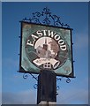
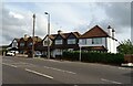
Eastwood sign, Rochford Corner
Eastwood "village" sign.
Image: © John Myers
Taken: 21 Jan 2007
0.12 miles
2
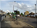
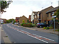
Bus stop and shelter on Rayleigh Road (A1015), Eastwood
Image: © JThomas
Taken: 25 Aug 2022
0.13 miles
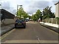
7
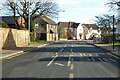
Green Lane, Eastwood
Parkway Close bus stops, on the left for route 9 Rayleigh - Shoeburyness, on the right vice versa.
Image: © Robin Webster
Taken: 5 Feb 2023
0.22 miles
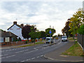
8
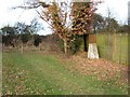
Triangulation Point at Nobles Green
This triangulation pillar stands on a small plot of land between houses on Green Lane. Running across the picture behind the wooden posts is a bridle path
Image: © Glyn Baker
Taken: 10 Feb 2006
0.23 miles