
IMAGES TAKEN NEAR TO
Symons Avenue, LEIGH-ON-SEA, SS9 5QE
Introduction
This page details the photographs taken nearby to Symons Avenue, SS9 5QE by members of the Geograph project.
The Geograph project started in 2005 with the aim of publishing, organising and preserving representative images for every square kilometre of Great Britain, Ireland and the Isle of Man.

There are currently over 7.5m images from over14,400 individuals and you can help contribute to the project by visiting https://www.geograph.org.uk
Image Map
Images are licensed for reuse under creativecommons.org/licenses/by-sa/2.0
Notes
- Clicking on the map will re-center to the selected point.
- The higher the marker number, the further away the image location is from the centre of the postcode.
Image Listing (8 Images Found)
Images are licensed for reuse under creativecommons.org/licenses/by-sa/2.0
Image
Details
Distance
4
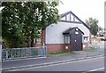
Eastwood Memorial Hall
A Memorial built to those who fell in the Great War.
On the Corner of Lambeth Road and Rayleigh Road, next to the Brook.
Image: © Paul Collins
Taken: 17 Jul 2007
0.14 miles
5
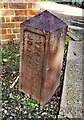
Old boundary marker, junction of Green Lane & Flemings Farm Road, Eastwood
South west face: County Borough of Southend on Sea
North east face: Rochford Rural District
No year included on either face
Milestone Society National ID: EX_SOUS13pb
Image: © Paul Jones
Taken: 4 Nov 2020
0.18 miles
8
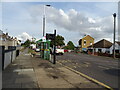
Bus stop and shelter on Rayleigh Road (A1015), Eastwood
Image: © JThomas
Taken: 25 Aug 2022
0.23 miles