IMAGES TAKEN NEAR TO
The Crest, LEIGH-ON-SEA, SS9 5NJ
Introduction
This page details the photographs taken nearby to The Crest, SS9 5NJ by members of the Geograph project.
The Geograph project started in 2005 with the aim of publishing, organising and preserving representative images for every square kilometre of Great Britain, Ireland and the Isle of Man.

There are currently over 7.5m images from over14,400 individuals and you can help contribute to the project by visiting https://www.geograph.org.uk
Image Map
Images are licensed for reuse under creativecommons.org/licenses/by-sa/2.0
Notes
- Clicking on the map will re-center to the selected point.
- The higher the marker number, the further away the image location is from the centre of the postcode.
Image Listing (12 Images Found)
Images are licensed for reuse under creativecommons.org/licenses/by-sa/2.0
Image
Details
Distance
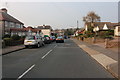
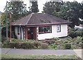
2
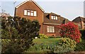
House and garden on Bellhouse Road, Eastwood
Image: © David Howard
Taken: 8 Apr 2019
0.11 miles
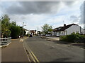
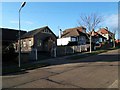
3
Bellhouse Road at the junction of Leighfields Road
Image: © David Howard
Taken: 8 Apr 2019
0.12 miles
5
Evangelical Church, Leigh-on-Sea
A small Evangelical Church in Leighfields Ave
Image: © Glyn Baker
Taken: 10 Feb 2006
0.15 miles
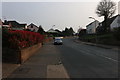
6
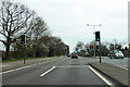
A127 towards Southend
At the Bellhouse Lane lights.
Image: © Robin Webster
Taken: 6 Apr 2018
0.19 miles
7
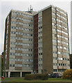
Beaver Tower, Mansell Close, Eastwood
Beaver Tower is one of Southend's thirteen tower blocks and was completed in the mid-1960s.
Image: © David Kemp
Taken: 28 Oct 2016
0.19 miles
9
Former Public Toilets, Eastwood
No appointment necessary. Hair cut at your convenience.
Image: © John Myers
Taken: 3 Sep 2007
0.20 miles