IMAGES TAKEN NEAR TO
Eastwood Rise, LEIGH-ON-SEA, SS9 5BS
Introduction
This page details the photographs taken nearby to Eastwood Rise, SS9 5BS by members of the Geograph project.
The Geograph project started in 2005 with the aim of publishing, organising and preserving representative images for every square kilometre of Great Britain, Ireland and the Isle of Man.

There are currently over 7.5m images from over14,400 individuals and you can help contribute to the project by visiting https://www.geograph.org.uk
Image Map
Images are licensed for reuse under creativecommons.org/licenses/by-sa/2.0
Notes
- Clicking on the map will re-center to the selected point.
- The higher the marker number, the further away the image location is from the centre of the postcode.
Image Listing (7 Images Found)
Images are licensed for reuse under creativecommons.org/licenses/by-sa/2.0
Image
Details
Distance
1
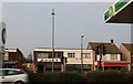
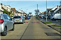
Mr Tang Chinese restaurant on Rayleigh Road, Eastwood
From the BP garage opposite
Image: © David Howard
Taken: 8 Apr 2019
0.10 miles
4
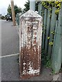
Old Boundary Marker
Municipal Boundary Marker on the pavement on the east side of Eastwood Rose, Leigh on Sea. On the current boundary of Rayleigh parish and Southend on Sea unitary authority. COUNTY BOROUGH OF / SOUTHEND-ON-SEA and RAYLEIGH URBAN / DISTRICT in vertical raised lettering on opposite sides.
Milestone Society National ID: EX_SOUS09pb
Image: © R Rothwell
Taken: 8 Sep 2020
0.15 miles
6
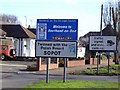
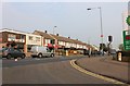
Welcome to Southend-on-Sea sign on Rayleigh Road
Lots of visitors from Sopot come here.
Image: © Julieanne Savage
Taken: 1 Feb 2007
0.23 miles
7
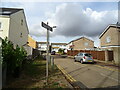
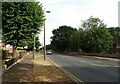
Bosworth Road, Eastwood
With a 20 mph speed limit and speed bumps.
Image: © Robin Webster
Taken: 5 Feb 2023
0.24 miles