IMAGES TAKEN NEAR TO
Eastwood Old Road, LEIGH-ON-SEA, SS9 4RY
Introduction
This page details the photographs taken nearby to Eastwood Old Road, SS9 4RY by members of the Geograph project.
The Geograph project started in 2005 with the aim of publishing, organising and preserving representative images for every square kilometre of Great Britain, Ireland and the Isle of Man.

There are currently over 7.5m images from over14,400 individuals and you can help contribute to the project by visiting https://www.geograph.org.uk
Image Map
Images are licensed for reuse under creativecommons.org/licenses/by-sa/2.0
Notes
- Clicking on the map will re-center to the selected point.
- The higher the marker number, the further away the image location is from the centre of the postcode.
Image Listing (5 Images Found)
Images are licensed for reuse under creativecommons.org/licenses/by-sa/2.0
Image
Details
Distance
1
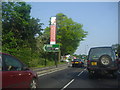
The A127 by the Progress Road Business Park
Image: © David Howard
Taken: 24 May 2012
0.12 miles
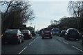
3
The A127, Eastwood
The pampas grass and flowers along the central reservation makes a great difference to the appearance of the road.
Image: © David Howard
Taken: 8 Apr 2019
0.20 miles
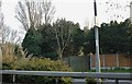
4
Progress Road, Eastwood
Going through the industrial estate
Image: © David Howard
Taken: 8 Apr 2019
0.21 miles
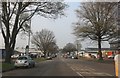
5
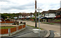
Thorndon Park Drive, Leigh-on-Sea
Taken from the junction with Linksway. Belfairs Woods can be seen on the horizon.
Image: © David Kemp
Taken: 9 May 2021
0.23 miles