IMAGES TAKEN NEAR TO
The Fairway, LEIGH-ON-SEA, SS9 4QP
Introduction
This page details the photographs taken nearby to The Fairway, SS9 4QP by members of the Geograph project.
The Geograph project started in 2005 with the aim of publishing, organising and preserving representative images for every square kilometre of Great Britain, Ireland and the Isle of Man.

There are currently over 7.5m images from over14,400 individuals and you can help contribute to the project by visiting https://www.geograph.org.uk
Image Map
Images are licensed for reuse under creativecommons.org/licenses/by-sa/2.0
Notes
- Clicking on the map will re-center to the selected point.
- The higher the marker number, the further away the image location is from the centre of the postcode.
Image Listing (6 Images Found)
Images are licensed for reuse under creativecommons.org/licenses/by-sa/2.0
Image
Details
Distance
1
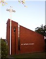
St. Aidans Church, Leigh-on-Sea
St. Aidans Church, Fairway, Leigh-on-Sea.
Image: © Paul Collins
Taken: 12 Sep 2007
0.12 miles
2
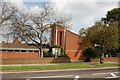
St Aidan's Parish Church, Leigh-on-Sea
Image: © Trevor Harris
Taken: 18 Sep 2008
0.13 miles
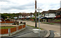
4
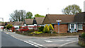
Linksway, Leigh-on-Sea
Taken from the junction with Broadlawn. Shows one of Southend's traditional oval-ended rectangular street signs adorned with a finial.
Image: © David Kemp
Taken: 9 May 2021
0.22 miles
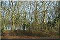
5
Thorndon Park Drive, Leigh-on-Sea
Taken from the junction with Linksway. Belfairs Woods can be seen on the horizon.
Image: © David Kemp
Taken: 9 May 2021
0.23 miles
6
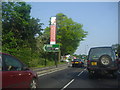
The A127 by the Progress Road Business Park
Image: © David Howard
Taken: 24 May 2012
0.25 miles