IMAGES TAKEN NEAR TO
Vardon Drive, LEIGH-ON-SEA, SS9 3SH
Introduction
This page details the photographs taken nearby to Vardon Drive, SS9 3SH by members of the Geograph project.
The Geograph project started in 2005 with the aim of publishing, organising and preserving representative images for every square kilometre of Great Britain, Ireland and the Isle of Man.

There are currently over 7.5m images from over14,400 individuals and you can help contribute to the project by visiting https://www.geograph.org.uk
Image Map
Images are licensed for reuse under creativecommons.org/licenses/by-sa/2.0
Notes
- Clicking on the map will re-center to the selected point.
- The higher the marker number, the further away the image location is from the centre of the postcode.
Image Listing (14 Images Found)
Images are licensed for reuse under creativecommons.org/licenses/by-sa/2.0
Image
Details
Distance
1
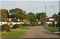
Vardon Drive, Leigh-on-Sea
Vardon Drive is a long cul-de-sac whose eastern 'dead' end is seen here.
Image: © David Kemp
Taken: 3 Oct 2015
0.04 miles
2
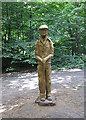
A 'Man of the Woods' in Belfairs Park Wood
This sculpture from a local tree trunk is one of several recently completed by a local artist in Belfairs Park Wood. The others include a 'Green Man' and several of local wildlife. The sculptures were commissioned using a grant from the Heritage Lottery Fund. A 'Man of the Woods' was one of those managing the woods as a Coppice-with-Standards. The felling axe he is holding would be the important tool of his trade. Coppice Management ended in Belfairs Park Woods in the 1930s, but has been recently re-started. It has, however, been continuously practised in the nearby Belfairs Nature Reserve for hundreds of years.
Image: © John Rostron
Taken: 7 Sep 2013
0.07 miles
3
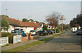
Vardon Drive, Leigh-on-Sea
Taken looking east from near the junction with Agnes Avenue.
Image: © David Kemp
Taken: 3 Oct 2015
0.11 miles
4
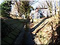
Prittle Brook, Leigh-on-Sea
This is a small weir and water monitoring station on the Prittle Brook Leigh-on-Sea
Image: © Glyn Baker
Taken: 10 Feb 2006
0.11 miles
5
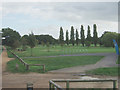
Belfairs Golf Course
As seen looking south-east from Belfairs Woodland Centre.
Image: © David Kemp
Taken: 17 Oct 2013
0.20 miles
6
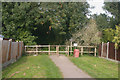
Entrance to Belfairs Woods off Vardon Drive, Leigh-on-Sea
OS and other maps show these woods as 'Belfairs Park' but locally the area is known as 'Belfairs Woods'.
Image: © David Kemp
Taken: 3 Oct 2015
0.20 miles
7
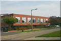
Belfairs Academy, Highlands Boulevard - south-west side
Belfairs Academy is a non-selective secondary school that opened as Belfairs High School in 1955. The present buildings date from 2011.
Image: © David Kemp
Taken: 3 Oct 2015
0.20 miles
8
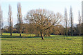
View from Belfairs Woodland Centre
Winter sunlight illuminates a tree at Belfairs Park Wood. The Belfairs Woodland Centre is run by the Essex Wildlife Trust.
Image: © Roger Jones
Taken: 17 Jan 2015
0.21 miles
9

Belfairs Academy, Highlands Boulevard - south side
Belfairs Academy is a non-selective secondary school that opened as Belfairs High School in 1955. The present buildings date from 2011.
Image: © David Kemp
Taken: 3 Oct 2015
0.22 miles
10
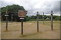
Grey Squirrel Assault Course
This rodentine puzzler outside Image has been set up to discourage visitors from feeding the squirrels. As yet not many have worked out the knack of getting through all the tests watch a video of what everyone is hoping to see in time at http://www.youtube.com/watch?v=nWU0bfo-bSY
Image: © Glyn Baker
Taken: 5 Jul 2014
0.23 miles